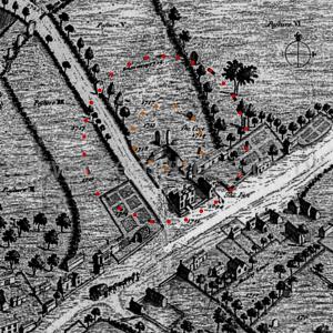
Europe, British Isles, South-West England, Wiltshire, Avebury Henge and Stones, Avebury Stone Circles, Avebury North Circle Cove [Map]
Avebury North Circle Cove is in Avebury North Circle, Avebury Type Cove.
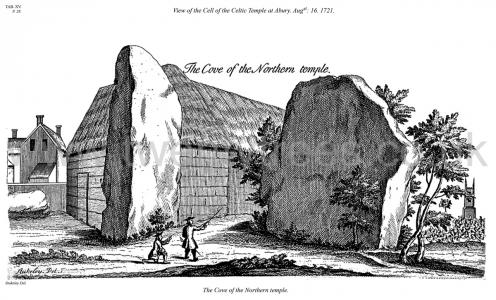
Avebury by William Stukeley. Table XV. View of the Cell of the Celtic Temple at Abury. Augst: 16. 1721. The Cove [Map] of the Northern temple.
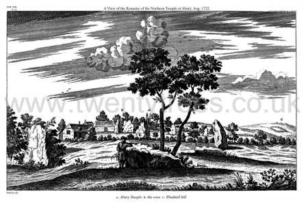
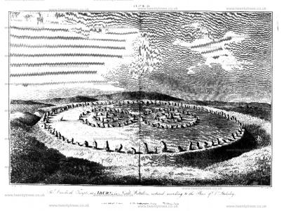
Avebury by William Stukeley. Table XIII. A View of the Remains of the Northern Temple at Abury. Aug. 1722. A. Abury Steeple. B. the cove [Map]. C. Windmill hill.
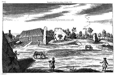
Avebury by William Stukeley. Table XIV. Prospect of the Cove [Map] Abury 10 July 1723.
Avebury by William Stukeley. Of the two great temples [Avebury South Circle and Avebury North Circle] included in the area of the great circle of stones. Each consists of two concentrick circles. One has a central obelisc or ambre, a very high stone in the center. The Egyptians called an obelisc an ambre. The other temple has a cove [Map] in the center, composed of three stones of a stupendous bulk, set in a nich-like figure. A short history of the destroyers of this noble work, but a very few years ago.
Avebury by William Stukeley. The centers of these two double circles are 300 cubits asunder. Their circumferences or outward circles are 50 cubits asunder, in the nearest part. By which means they least embarrass each other, and leave the freest space about 'em, within the great circular portico (as we may call it) inclosing the whole; which we described in the former chapter. There is no other difference between these two temples (properly) which I could discover, save that one, the southermost, has a central obelisc, which was the kibla, whereto they turned their faces, in the religious offices there performed: the other has that immense work in the center, which the old Britons call a cove [Map]: consisting of three stones placed with an obtuse angle toward each other, and as it were, upon an ark of a circle, like the great half-round at the east end of some old cathedrals: or like the upper end of the cell at Stonehenge [Map]; being of the same use and intent, the adytum of this temple. This I have often times admired and been astonished at its extravagant magnitude and majesty. It stands in the yard belonging to the inn. King Charles II. in his progress this way, rode into the yard, on purpose to view it.
Colt Hoare 1812. Plate XII represents a ground plan of the Grand Circle at Abury, taken by Dr. Stukeley (age 36) in the year 1724.; but from the inaccuracy of its outline, and the position of the two concentric temples, I doubt whether this plan was taken from actual survey1. It is, however, particularly interesting to the present age, as recording the state the circle at, a distant period, when it appears to have had eighteen stones standing, and twenty-seven fallen of the outward circumvallation; two standing, and nine fallen of the outward circle of the Northern Temple; one standing, and five fallen of the Inner Circle, and two out of three large upright stones that formed the COVE [Map]. Of the adjoining Southern Temple, four stones of the outward circle were standing in their original situation, and seven were fallen down; but one stone alone remained standing of the interior circle.
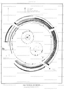
Colt Hoare 1812. Plate Xl. By this plan I have been anxious to convey to my readers, correct idea of the grand circle at Abury in its original state, as most ingeniously developed by Dr. Stukeley. The site of the temples is taken from nature. The fine British earth-work called Oldbury Castle, appears at a distance in the centre of the view. The object of this Plate is to indicate the respective site of each temple; and the number of stones with which each composed; thirty in the out-ward, and twelve in the inner circles. The one situated towards the north, or right hand side, had three large upright stones in the centre of its area, designating the COVE [Map], where the altar was placed. The centre of the Southern Temple was marked by an upright stone named the OBELISK [Map], in a line with which, and between the temple and the outward circumvallation, was another single stone, with a perforation in it and denominated by Stukeley, the RING STONE [Map]. To this he supposes the victim was fastened previous to its sacrifice. The stones that accompanied the outward circumvallation, amounted to one hundred. The breaks in the vallum A. [Map] B. [Map] point out the spots where the two avenues issued from the central Temple; the one on the left side leading to Kennet; the other towards the centre to Beckhampton.
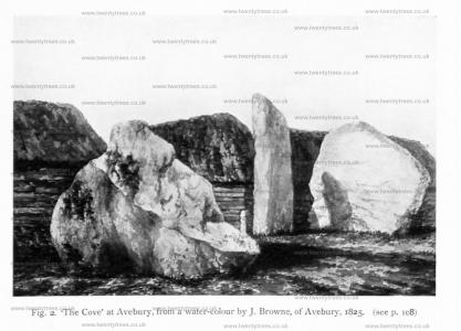
Archaeologia Volume 84 1935 Section VI. 1825. Plate XXXIII. Fig. 2. ‘The Cove [Map]’ at Avebury, from a water-colour by J. Browne, of Avebury.
Diary of a Dean by Merewether. It may be deemed no unprofitable appropriation of our space and time, to give a brief statement of the number of stones originally composing this magnificent temple, what Dr. Stukeley observed, and what we have found there.
The original outer circle was formed of 100 stones; within this were two smaller circles [Avebury North Circle and Avebury South Circle], not concentric, of (each) 30 stones; within each of these a smaller concentric circle, each of 12 stones; in the centre of the northern inner circle were 3 stones [Map]; in the centre of the southern inner circle 1 stone [Map].
Besides these, each avenue was composed of 200 stones, terminating towards the east on Hacpen Hill, in a double oval, the outer containing 40 stones, the inner 18 stones; in the western range were 2 extra stones about half way, forming as it were a recess; and 1 at the termination.
Diary of a Dean by Merewether. The number of stones in the outer circle at present erect is 7, prostrate 5; of one or two of these the stumps only remain, the rest having been broken off. Of the stones of the southern circle 2 only remain erect, 3 prostrate; none of its inner circle. Of the stones of the northern circle 3 remain erect, 1 prostrate; of its inner circle 2 prostrate; of the central cove [Map] 2 erect, and these are the tallest of all.
Wiltshire Archaeological Magazine 1857 V4 Pages 307-363. Within the northern of these circles, in its centre, were three very large stones which formed the Adytum or Cove of the Temple [Map], as Stukeley termed it. 'These were plac'd with an obtuse angle towards each other, and as it were, upon an ark of a circle, like the great half-round at the east end of some old Cathedrals."1 Of these two remain, standing at an angle of about 110 degrees. The' third, 7 yards in length, fell in 1713, and was broken up. The taller of the two is 17 feet high, 7 feet 7 inches wide, and 2 feet 4 inches thick. The other is 14 feet 7 inches high, 14 feet 7 inches wide, and 4 feet thick. "The altar properly lay upon the ground before this superb nich. That no doubt was carry'd off long ago, as not being fix'd in the earth."2 The late Mr. Brown of Amesbury says, "Before the central one of the three, facing, (like the altar trilithon of Stonehenge) the north east, was placed the stone on which the sacrifices were burnt. This I ascertained myself by digging, the place being still apparent where it lay, but now filled up with rubbish."3 In an interesting paper on the state of Abury in 1829, in the Gentleman's Magazine, Mr. Joseph Hunter states that he was informed by a labourer that the earth had been examined to the depth of a yard or more, at the foot of these stones, to see if there were any evidences of sacrifices having been performed there, but nothing peculiar was observed.
Note 1. Stukeley's Abury, p. 23. "The vulgar call them 'the Devil's brand irons.'" p. 24,
Note. Ditto.
Note 3. Brown's Stonehenge and Abury, 4th edition, p. 34.
Wiltshire Archaeological Magazine 1866 V10 Pages 209-216. Our next point, and one of considerable interest, was at the Cove [Map], within the circle: here we sunk four large holes, within the rickyard: Mr. Brown in the most obliging manner having a small straw rick removed which stood in our way. The first hole was sunk at the foot of the large massive western stone of the Cove (marked "a" in the map), on its eastern side. Here we discovered a layer of blocks of sarsen stones, varying in size from a few inches square, to fourteen or eighteen inches in length, by eight or nine inches in diameter. These were evidently placed there, and rammed in for the purpose of propping the massive stone in its upright position. On digging on the other (the west) side of the same stone, we found a continuation of the same layer of sarsen blocks. The next hole was dug close to the tall upright stone ("b" in the map); this disclosed the same sarsen foundations as in the other instance. The fact that these stones were thus supported, has not, as far as I am aware, been hitherto observed.
In digging near the large stone, we noticed at a spot about a foot below the surface, a quantity of black charred matter. This discovery induced us to extend our operations by digging a large trench from this spot in an east north east direction, ten feet from the great western stone: and throughout this distance we found numerous large flakes and chips of sarsen, covered with black charred matter and burnt straw, or other material; but beyond this it ceased, and the ground appeared undisturbed as in other parts. But again we came upon more burnt matter and more charred stones in a hole we dug farther on in the same direction, viz., E.N.E., from the great western stone. Here there apparently stood the third stone of the Cove, exactly equidistant from the inside centre of the remaining two; and the fire of destruction having been lit (as was customary) beneath it, it fell towards the western stone, where again other fires were lit for breaking up the upper portion, and hence the chippings or flakes and burnt matter in that immediate spot. At first I was inclined to attribute these flakes to the remains of an " Altar stone," which might have once stood in the centre of the three stones of "the Cove," and since have been destroyed, but this theory is not supported by any tangible facts. We now sunk another hole due east of the large western stone of the Cove, on the supposition that the tall stone standing due south, might have been flanked by large stones east and west, but we came upon no trace of any stone having ever stood in that position. A good deal of British pottery, and many animal bones; sheep, horse, ox, and dog, were found in ail of these holes, more especially in the latter, but no human bones whatever. I should add, that above the natural soil within the Cove, now a rick-yard, an accumulation of chalk rubble covers the surface of the ground to the depth of above a foot.
Avebury North Circle is 98m diameter Stone Circle. Only two of its stones are extant.
The North Circle may have been two circles, one within another, concentric, with the cove [Map] at its centre as shown on the Frontspiece to Stukeley's Chapter 5 where he has also shown the years in which the stones were destroyed ranging from 1694 to 1718. Stukeley's drawing shows and outer circle of twenty-eight stones and an inner circle of eleven stones.
