Europe, British Isles, South-West England, Wiltshire, Boyton [Map]
Boyton, Wiltshire is in Wiltshire.
Around 1246 Hugh Giffard died at Boyton, Wiltshire [Map].
Before 20 May 1282 John Neville (age 42) died at Boyton, Wiltshire [Map].
On 29 May 1299 John Giffard 1st Baron Giffard Brimpsfield (age 67) died at his home in Boyton, Wiltshire [Map]. His son John Giffard 2nd Baron Giffard Brimpsfield (age 11) succeeded 2nd Baron Giffard Brimpsfield. Aveline Courtenay Baroness Giffard Brimpsfield (age 18) by marriage Baroness Giffard Brimpsfield.

Hugh Giffard was born to William Giffard at Boyton, Wiltshire [Map].
The River Wylye rises on the White Sheet Downs, Wiltshire [Map] from where it flows past Kingston Deverill, Wiltshire [Map], Monkton Deverill, Wiltshire [Map], Brixton Deverill, Wiltshire [Map], Hill Deverill, Wiltshire [Map], Longbridge Deverill, Wiltshire [Map], one kilometre south of Warminster, Wiltshire [Map], Bishopstrow, Wiltshire [Map], Norton Bavant, Wiltshire [Map], Heytesbury, Wiltshire [Map], Upton Lovell, Wiltshire [Map], Boyton, Wiltshire [Map], Sherrington, Wiltshire [Map], Codford St Mary, Wiltshire [Map], Fisherton de la Mere, Wiltshire [Map], Wylye, Wiltshire [Map], Steeple Langford, Wiltshire [Map] after which it is joined by the River Till at Serrington, Wiltshire [Map].
Thereafter it flows around Great Wishford, Wiltshire [Map], South Newton, Wiltshire [Map] to Wilton, Wiltshire [Map] where it joins the River Nadder.
Europe, British Isles, South-West England, Wiltshire, Boyton Barrow 1 [Map]
Boyton Barrow 1 is also in South England Bronze Age.
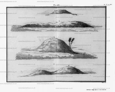
Archaeologia Volume 15 Section XXXIII. The next barrow [Boyton Barrow 1 [Map]] opened, was the large circular one standing on the edge of Boyton Downs, and about 70 yards north of the great long barrow [Boyton Down Long Barrow [Map]] [d] on Sherrington manor, the boundary line running near the latter barrow.
This circular tumulus is 76 feet in the base diameter, and elevated 14 feet above the plain; being situated on high ground, it commands extensive views to the north and east. See Plate XVI. fig. 3. To open this barrow, we made a large section from north to south: in the first stratum, about two feet thick, composed chiefly of vegetable earth, we discovered nine skeletons lying in different directions. [e] Some years ago, your grandfather ordered some trees to be planted on this barrow, when the men employed in this work discovered four skeletons, which were afterwards interred in Boyton church-yard; therefore the whole number of bodies discovered on the top of this tumulus were thirteen. After we had worked through this stratum of vegetable mould, we came to another of small loose flints, similar to what are now picked off the arable land in this neighbourhood, for mending the roads; the latter was more than four feet thick. We next came to a stratum of black vegetable earth, which continued till we came to the bottom, at the depth of eight feet more, (viz. fourteen feet from the surface): here, and nearly in the centre of the barrow, in a shallow ciff, in the original soil, lay the burnt bones of the Briton for whom the tumulus was erected: they were piled in a small heap, but without any arms, urn, or trinkets. It is rather extraordinary, that notwithstanding the long space of time these bones must have lain in the damp earth, yet they were to all appearance as white, and handled as dry, as though recently interred, [f].
Note d. Plate XVI. Fig. 2.
Note e. Part of these skeletons lay with their heads to the north, and others to the south, but apparently in no regular order.
Note f. I do not mention this circumstance as peculiar to this barrow, as it is very frequent.

Archaeologia Volume 15 Section XXXIII. Archaeologia Volume 15 Plate XVI: 1. Boyton Barrow 2 [Map], 2. Boyton Down Long Barrow [Map], 3. Boyton Barrow 1 [Map], Corton Long Barrow [Map] South View,

Europe, British Isles, South-West England, Wiltshire, Boyton Barrow 2 [Map]
Boyton Barrow 2 is also in South England Bronze Age.
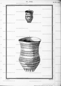
Archaeologia Volume 15 Section XXXIII. The third, a circular tumulus [Boyton Barrow 2 [Map]], see Plate XVI fig. I. in Boyton manor, is situated on a neck of land, projecting from the great ridge wood, to Stockton sheep pond, having Dean Valley on the right. This barrow is 40 feet in diameter, and 3 feet nine inches in elevation; at the depth of four feet in the native chalk, (7 feet 9 inches from the top of the barrow,) we found the skeleton of a young person [h] lying with the head nearly east, this circumstance is unusual in what I have supposed primary interments, viz. where skeletons are interred at a great depth in a barrow; in such cases the head generally lies to the north, or nearly so. [i] The bones were in very good prefervation, and the teeth, (a most beautiful set,) were perfectly white. Near the feet of this skeleton, lay the fragments of a very handsome drinking cup; [k] about a foot from this, we found another very small cup, both of which I have since repaired by a cement, which has enabled Mr. Crocker to make good drawings of both.
The large cup, [l] or vase, holds nearly two quarts: it is of a brick colour, and on first sight might be mistaken for the Roman Samian pottery, but, on a nearer view, you perceive (notwithstanding the neat appearance,) that it is very imperfectly burnt, and that the ornaments are done by the hand, without a lathe; it stands 9 inches high, and measures 6 inches over the brim, see Plate XVII. Fig. 1. The small black cup is, in size and form, like some modern cream pots; it is 3¼ inches high; see Fig. 2.
Note h. I suppose from 20 to thirty years of age.
Note i. On top of barrows, we find the fkeletons in every direction.
Note k. The wide brim and large size rather militate against appropriating those vessels to this purpose.
Note l. This is the largest drinking cup I ever saw.


Archaeologia Volume 15 Section XXXIII. Archaeologia Volume 15 Plate XVI: 1. Boyton Barrow 2 [Map], 2. Boyton Down Long Barrow [Map], 3. Boyton Barrow 1 [Map], Corton Long Barrow [Map] South View,

Europe, British Isles, South-West England, Wiltshire, Boyton Down Long Barrow [Map]
Boyton Down Long Barrow is also in South England Neolithic Long Barrows.
Archaeologia Volume 15 Section XXXIII. Archaeologia Volume 15 Plate XVI: 1. Boyton Barrow 2 [Map], 2. Boyton Down Long Barrow [Map], 3. Boyton Barrow 1 [Map], Corton Long Barrow [Map] South View,

Wiltshire Archaeological Magazine 1913 V38 Pages 379-414. Sherrington. 4. [Boyton Down Long Barrow [Map]] On the Boyton — Sherrington parish boundary, S. of Boyton Church, E. of Boyton Field Barn, on a conspicuous ridge of down. Length 150ft.; E. and W. No recorded opening. It is shown on Hoare's Map of Wylye Station (S. of the village of Boyton) as opened, but there seems to be no mention of it in the text. It is not included in Thurnam's list of long barrows opened by Hoare and Cunnington, and there is only an incidental mention of it in Wm. Cunnington's account of "Barrows opened on the Manors of Corton, Boyton, and Sherrington " (Arch. xv. 338) although a sketch of the barrow is given on Pl. XVI. fig. 2. Only the fringe and a few feet at the western end of the mound remain, but it must once have been a very fine barrow, and very conspicuously situated. The mound appears to have been wide and high for its length, the width at the east end being now 64ft. It stands on cultivated ground with no trace of the ditches above ground. Labourers on the spot stated that the material of the mound had been taken away from time to time to mend the adjacent trackway. O.M. 58 NE.; Arch. xv. 340, PL VI. fig. 2; A.W. I. Map of Wylye Station.