Text this colour is a link for Members only. Support us by becoming a Member for only £3 a month by joining our 'Buy Me A Coffee page'; Membership gives you access to all content and removes ads.
Text this colour links to Pages. Text this colour links to Family Trees. Place the mouse over images to see a larger image. Click on paintings to see the painter's Biography Page. Mouse over links for a preview. Move the mouse off the painting or link to close the popup.
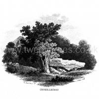
Croesllechau Long Barrow is in Bronllys, Prehistoric Wales Neolithic Burials.

Long Barrows of the Cotswolds. Croesllechau [Map]
Brecknockshire, 23 S.W. Parish of Bronllys. 3*.
Latitude 52° 01' 93". Longitude 3° 12' 49". Height above O.D., 400 feet.
"In a field called Croeslechau about two miles eastward of this town or village [Talgarth] but in the parish of Bronllys and on a farm called Bryn-y-groes, is a cromlech, not merely interesting on account of its antiquity, but from the circumstance of a white thorn growing close, and indeed under part of it, which has gradually raised the horizontal or covering-stone several inches out of its original position; it is therefore not only venerable as a relic of very ancient days but as a natural curiosity." So wrote Theophilus Jones in 1809, and put a drawing of the "cromlech" on his title-page. In 1832 (but not before) the site was marked on the engraved one-inch O.S. map, from which the co-ordinates given above have been taken. Now the site is unknown and all memory of it has completely vanished in the neighbourhood. Mr. Evan Morgan has visited the site and reports that no traces of the "cromlech" were visible; nor were enquiries of the farmer at Bradwys any more successful in identifying the site. It is not unlikely that the monument was destroyed when a new road was made at some date probably very soon after 1832. It appears that Bryn-y-groes Farm was situated about 200 yards S.W. of Lower Barn, where a house stood about 80 to 100 years ago; on the old MS. 2" map of 1814 the farm of Bryn-y-groes is marked close to where the site of Croesllechau is marked on the 1832 edition.
Theophilus Jones, Hist. of the County of Brecknock, VoL II. 1809, p, 338 (vignette on title-page, reproduced on opposite plate).