Europe, British Isles, England, Welsh March, Gloucestershire, Avening
Avening, Gloucestershire is in Gloucestershire.
Europe, British Isles, England, Welsh March, Gloucestershire, Norn's Tump aka Avening Long Barrow [Map]
Norn's Tump aka Avening Long Barrow is also in Cotswolds Neolithic Tombs.
Norn's Tump aka Avening Long Barrow [Map]. Historic England 1008196
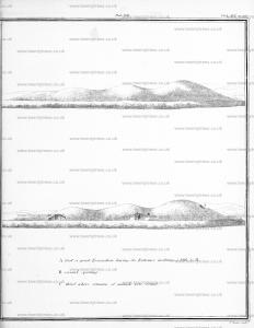
The monument includes a chambered long barrow situated on a plateau in the area of the Cotswold Hills with views over the Avening Valley to the south, gently sloping land to the north and the adjacent ridge to the south-east. The barrow, which is known as Norn's Tump, has a mound trapezoidal in plan and orientated east-west; it has dimensions of 52m from east to west and 25m from north to south. The mound is composed of small stones and has a maximum height near to the centre of 2.5m. An early illustration of the barrow suggests that it had two side chambers, both of which were visible in 1911. There are two large depressions on the southern side of the barrow's mound which could mark the position of these chambers. The mound is flanked on each side by a ditch from which material was quarried during the construction of the monument. These have become infilled over the years, but will survive as buried features c.5m wide. Excluded from the scheduling are all hedges, dry-stone walling and fence posts relating to the land boundaries, although the ground beneath these features is included.
Archaeologia Volume 16 Appendix. November 20, 1806. The Rev. W. H. Thornbury, in two letters addressed to the Rev. John Brand, M. A. Secretary, and William Bray, Esq. Treasurer of the Society, sent an account of a Barrow [Norn's Tump aka Avening Long Barrow [Map]], opened in the parish of Avening, in Gloucestershire, whose length, from east to west, was fifty-five yards, the greatest breadth nineteen two-thirds, and the smallest twelve yards and one-third; having within it two small chambers, in one of which were found eight, and in the other three skeletons, but no celts or other remains, except some bones of animals, which were buried in the Tumulus at C. Pl. LVII.
Mr. Fosbrook, F. A. S. in a letter addressed to the Society, observes, that as none of the characteristic marks of its being Danish, Saxon, or Roman exist, it may possibly be British, and have been formed before the Roman invasion.

Proceedings of the Cotteswold Naturalists' Field Club Volume 5 Page 277. The Avening Tumulus [Map] (No. 6) was opened in the year 1809 by the Rev. N. Thornbuky, Rector of Avening; three stone chambers were taken out, removed to a grove in the rectory garden, and there carefully set up in the forms and relative positions they had occupied in the tumulus, so that even in their present state they afford good examples of such sepulchral chambers. The largest is 7 feet long, 7 feet wide, and 4 feet high, and has one side formed by two stones so placed as to give access to the chamber.
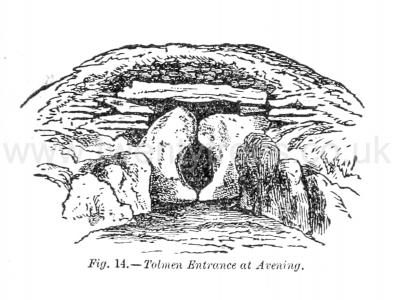
Description of the Chambered Tumuli of Uley and Nympsfield. Avening [Map]. — The tumulus at Avening was opened in 1806 by the Rev. W. H. Thornbury, who communicated the result to the Society of Antiquaries.1 The length of this barrow, from east to west, was 165 ft., the greatest breadth was 59 ft., and the smallest 37 ft. Two chambers were found, in one of which were discovered eight, and in the other three, skeletons. No implements, or other remains, were found, except some bones of animals. As regards the crania no information is given. These matters were not then so closely attended to as at present. It had a tolmen entrance, similar to that above described (see fig. 14), and Fosbroke, who was present at the opening, observes: "the structure was obviously adapted to the object of successive interments j the practice having evidently been to dig away the soil which filled the approach, to insert the body in the vault, and cover all up as before.2
Note 1. Archæol. Vol. XVI , p. 362.
Note 2. Encycl. Antiq , 1843, pp. 544, 547.

2 Avening Barrow. Avening Barrow [Map]
This lies half a mile to the east of the village of Avening, and two and a half miles from Nailsworth. It is 160 feet long, its greatest width being 60 feet, and greatest height 6 feet. Its direction is east and west, the highest portion of the barrow being at the east end. It was opened in the year 1809 by the Rev. N. Thornbury, Rector of Avening. Three stone chambers were taken out and removed to a grove in the rectory garden, where they are carefully preserved.
See "Archaeologia," vol. XVI, p362.
Long Barrows of the Cotswolds. Norn's Tump aka Avening Long Barrow [Map]
Europe, British Isles, England, Welsh March, Gloucestershire, Avening, The Tingle Stone [Map]
The Tingle Stone is also in Cotswolds Neolithic Tombs.
The Tingle Stone [Map]. Historic England:
The monument includes a long barrow known as the Tingle Stone situated in the Cotswold Hills below the crest of a ridge overlooking a valley to the south. The barrow has a mound composed of small stones orientated north-south with maximum dimensions of 40m in length, 20m in width and a maximum height of c.2m. This is flanked on each side by a ditch from which material was quarried during the construction of the monument. These have become infilled over the years, but survive as buried features c.5m wide. The site is named after the standing stone which is situated towards the northern end of the monument. This stone is a block of oolitic limestone orientated north-south with a maximum height of 1.5m above ground level and dimensions of 0.6m by 0.3m. There are reports of coins having been recovered from the site of the barrow prior to 1789, although there are no records of an excavation. The long barrow represents one of at least three long barrows which occur as a dispersed group in the vicinity.
Proceedings of the Cotteswold Naturalists' Field Club Volume 5 Page 277. Near Gatcombe Park there is another tumulus (No. 6 of the foregoing table) [The Tingle Stone [Map]] which is interesting as forming in several respects an exception to the other oval tumuli of the district. It does not occupy, as the others do, the highest level of its neighbourhood, for, although placed on a slight knoll, it is overlooked from rising ground on its eastern side. In its direction also it is exceptional, being placed due N. and S., the broadest part being at about one-third of the entire length from the north end of the mound. It is also the only example in the district of a crowned burrow, — on the broadest part stands a large stone, 6 feet in height, which bears the name of "Tingle Stone [Map]."
33 Tinglestone Barrow. Tinglestone Barrow [Map]
This lies near Gatcombe Park, half a mile north of the village of Avening, and one and a half miles from Minchinhampton. It is 130 feet long, 70 feet wide, and six feet high; its direction is north and south, the highest part being towards the north. It does not occupy, as the others do, the highest ground in the locality, for although it stands on a slight knoll it is overlooked from rising ground on its eastern side. It is also peculiar as being a crowned barrow. On the broadest portion of the mound stands a large stone six feet in height, which bears the name of the "Tingle Stone."
See "Proceedings Cott. Nat. Field Club," vol. V, p280.
Also Bigland's "Gloucestershire," p92.
Also "Flint Chips," p494.
Long Barrows of the Cotswolds. The Tingle Stone [Map]