Europe, British Isles, South-West England, Wiltshire, Winterbourne Monkton, Monkton Fields Long Barrow [Map]
Monkton Fields Long Barrow is in Winterbourne Monkton, Wiltshire [Map], Avebury Long Barrows North.
It is a curious fact that Five Wells Chambered Tomb [Map] is, within 0.2 of a degree of longitude, north of Stonehenge [Map] - see Five Wells Chambered Tomb and Stonehenge Alignment. Moreover, this line of longitude, give or take 500m, has the highest number of Neolithic and Early Bronze Age Monuments on it when compared to other lines of longitude. North to South:
Five Wells Chambered Tomb [Map]
Monkton Fields Long Barrow [Map]
Netheravon 6 Long Barrow [Map]
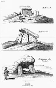
Avebury by William Stukeley. Table XXXVII. Kist vaen In Cornwal, In Cornwal, In Monkton field [Map] by Abury

Avebury by William Stukeley. In Monkton-fields, directly north-east from Abury, is a monument [Monkton Fields Long Barrow [Map]] of four stones, which probably is a kist-vaen. I have exhibited a print of it in table XXXVII. These seem to be what Mr. Edward Llwyd calls Kromlechon, or bowing-stones. I believe it was a sepulchral monument, set on a barrow, tho' chiefly now plowed up; and that the great covering-stone is luxated.
 Table XXXVII. Kist vaen In Cornwal, In Cornwal, In Monkton field [Map] by Abury
Avebury by William Stukeley. 1724. Not far from the Druid's barrow I saw a square work, such as I call Druids' courts or houses. Such near Stonehenge and Abury. 'Tis a place 100 cubits square, double-ditched. The earth of the ditches is thrown inward between the ditches, so as to a raise a terrace, going quite round. The ditches are too inconsiderable to be made for defence. Within are seemingly remains of stone walls. 'Tis within sight of the temple, and has a fine prospect all around, being seated on the highest part of the ridge. A little further is a small round barrow, with stone-work at the east end, like that before spoken of near Rowldrich; a dry stone wall or fence running quite over it, across the heath.
Return we nearer to the temple, and we see 300 paces directly east from it in the same field, a remarkable monument [Whispering Knights Burial Chamber [Map]?] much taken notice of; 'tis what the old Britons call a Kist vaen or stone chest; I mean the Welsh, the descendants of those invaders from the continent, Belgæ, Gauls and Cimbrians, who drove away the aboriginal inhabitants, that made the works we are treating of, still northward. Hence they gave them these names from appearances; as Rowldrich, the wheel or circle of the Druids; as Stonehenge they called choir gaur, the giants' dance; as our saxon ancestors called it Stonehenge, the hanging-stones, or stone-gallows. Every succession of inhabitants being still further removed from a true notion and knowledge of the things.
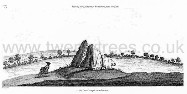
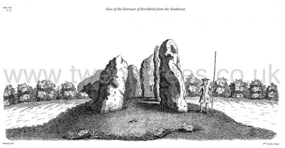
Our Kist vaen is represented in plates VI. and VII. One shews the foreside, the other the backside; so that there needs but little description of it. 'Tis composed of six stones, one broader for the back-part, two and two narrower for the sides, set square to the former; and above all, as a cover, a still larger. The opening is full west, to the temple, or Rowldrich. It stands on a round tumulus, and has a fine prospect south-westward down the valley, where the head of the river Evenlode runs. I persuade myself this was merely monumental, erected over the grave of some great person there buried; most probably the king of the country, when this temple was built. And if there was any use of the building, it might possibly be some way accommodated to some anniversary commemoration of the deceased, by feasts, games, exercises, or the like, as we read in the classic poets, who describe customs ancienter than their own times. It is akin to that Kist vaen in Cornwall, which I have drawn in plate XXXVII.
 Table VI.
 Table VII. View of the Kistvaen of Rowldrich from the Southwest.
 Table XXXVII. Kist vaen In Cornwal, In Cornwal, In Monkton field [Map] by Abury
Wiltshire Archaeological Magazine 1854 V1 Pages 303-304. Tumulus [Monkton Fields Long Barrow [Map]] at Winterbourne-Monkton. Discovery of an Ancient Tumulus, At Winterbourne-Monkton.
A curious, and possibly important discovery, exhibiting one of the ancient modes of sepulture in this country, has recently been made at Winterbourne-Monkton, about three hundred yards west of "Mill-barrow [Map]," and a mile and-a-half north of Avebury.
For many years a large flat Sarsen stone [Monkton Fields Long Barrow [Map]] (partially seen above the surface of the ground) had been the cause of many ungentle maledictions from the various clod-hoppers, who, from time to time, have followed the plough’s-tail in this particular locality. Forbearance being worn out, Mr. Eyles, the present occupier of the land, by whose kindness and assistance we have been allowed to investigate the spot, sent several men to dig a large hole on one side of it,—in fact to bury it. Indoing this they found the soil beneath the stone to be of a different quality from the natural subsoil; which is here chalk marl. They consequently excavated part of the earth and found several human bones, when night put an end to their operations. This discovery led to a more minute investigation, the results of which are as follows:—
The stone is lying flat, and is of considerable size, measuring nine feet four or five inches, each way, and varying from two feet six inches, to nearly four feet in thickness. By removing the soil beneath the stone we discovered a chamber dug in the natural chalk about seven or eight feet in diameter, somewhat circular in shape, and four feet in depth measuring from the under surface of the stone. This chamber was paved at the bottom with small irregularly shaped Sarsen stones, placed so closely that a ‘pick’ could with difficulty be inserted between them. On this pavement were four or five human skeletons, in a most confused state, covered with Sarsen stones, weighing from ten pounds to a half a ewt. each, and about twenty or thirty in number—over these again was a layer of mould up to the top stone which covered all. The skeletons did not seem to have been deposited in any particular direction. The skulls, thigh-bones, &c., were in such close proximity that one would suppose they were originally placed in a sitting posture, when the weight of stones and earth would naturally force them into the apparently confused state in which we found them. The jaw bones were in excellent preservation, as were also the teeth. One jaw evidently belonged to a child, as the second teeth are not cut, but remain still in the jaw.
Wiltshire Archaeological Magazine 1857 V4 Pages 307-363. In a field about 300 yards west of Mill barrow was the large sarsen [Monkton Fields Long Barrow [Map]], upon the removal of which several skeletons were found a few years ago. Since this discovery (which is described in the Wiltshire Archeological Magazine, vol. i. p. 303,) several other sarsen stones have been taken up in the same field, with similar results. With one of these deposits were jet ornaments, objects of stone and pottery, including two drinking cups,now preserved in the Society's Museum at Devizes.
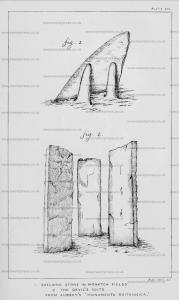
"In Monkton fields," says Aubrey (in his Monumenta Britannica), "is a long pitched stone seven foot and more; it leaneth eastward upon two stones. It is called Shelving stone."2 (Plate viii. fig. 1. and Stukeley's plate xxxvii.) This too has been removed within a few years.
Note 1. "A Kist-vaen certainly sepulchral," says Sir R, C. Hoare. This, however, may be doubted, as Mr. Hillier, of Monkton, last year examined the site of these stones, but found no traces of burnt bones, or of any thing to show that there had been an interment on the spot. It would be more correctly termed a Cromlech. It is shown in the foreground of the plate of Abury restored, given by Mr. Britton, 'Beauties of Wilts', vol. iii. 1825, p. 280; see p. 276, note.

Wiltshire Archaeological Magazine 1913 V38 Pages 379-414. Winterbourne Monkton. 8. [Monkton Fields Long Barrow [Map]] On Monkton Down. Length 80ft.; E. and W. Opened by Dean Merewether but no burial found. Not ploughed; in good condition and apparently not touched since Dean Merewether's time; there are four sarsen stones still to be seen at the western end; there is no sign of ditches. O.M. 28 NW.; Smith p. 126, X. H. iii. b.; Proc. Arch. Inst. Salisbury 104 (barrow No. 26).