Europe, British Isles, South-West England, Wiltshire, Old Sarum [Map]
Old Sarum is in Wiltshire.
Around 550. Gewisse was an Anglo-Saxon kingdom based in the upper Thames region around Dorchester on Thames, Oxfordshire [Map]. In 552 the Gewisse captured Old Sarum [Map]. In 556 the Gewisse captured Barbury Castle [Map].
Anglo-Saxon Chronicle. 552. This year Cynric fought with the Britons on the spot that is called Sarum [Map], and put them to flight. Cerdic was the father of Cynric, Cerdic was the son of Elesa, Elesa of Esla, Esla of Gewis, Gewis of Wye, Wye of Frewin, Frewin of Frithgar, Frithgar of Brand, Brand of Balday, Balday of Woden. In this year Ethelbert, the son of Ermenric, was born, who on the two and thirtieth year of his reign received the rite of baptism, the first of all the kings in Britain.
Anglo-Saxon Chronicle. 1003. This year was Exeter, Devon [Map] demolished, through the French churl Hugh, whom the lady had appointed her steward there. And the army destroyed the town withal, and took there much spoil. In the same year came the army up into Wiltshire. Then was collected a very great force, from Wiltshire and from Hampshire; which was soon ready on their march against the enemy: and Alderman Elfric should have led them on; but he brought forth his old tricks, and as soon as they were so near, that either army looked on the other, then he pretended sickness, and began to retch, saying he was sick; and so betrayed the people that he should have led: as it is said, "When the leader is sick the whole army is hindered." When Sweyne saw that they were not ready, and that they all retreated, then led he his army into Wilton; and they plundered and burned the town. Then went he to Old Sarum [Map]; and thence back to the sea, where he knew his ships were.
Anglo-Saxon Chronicle. 1086. This year the king (age 58) bare his crown, and held his court, in Winchester, Hampshire [Map] at Easter; and he so arranged, that he was by the Pentecost at Westminster, and dubbed his son Henry (age 18) a knight there. Afterwards he moved about so that he came by Lammas to Sarum [Map]; where he was met by his councillors; and all the landsmen that were of any account over all England became this man's vassals as they were; and they all bowed themselves before him, and became his men, and swore him oaths of allegiance that they would against all other men be faithful to him. Thence he proceeded into the Isle of Wight [Map]; because he wished to go into Normandy, and so he afterwards did; though he first did according to his custom; he collected a very large sum from his people, wherever he could make any demand, whether with justice or otherwise.
Anglo-Saxon Chronicle. 1106. At Easter was the king (age 38) at Bath, Somerset [Map], and at Pentecost at Salisbury [Map]; because he would not hold his court when he was beyond the sea.
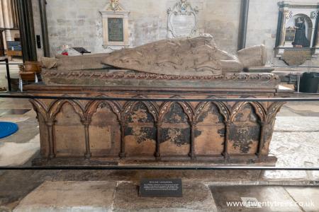
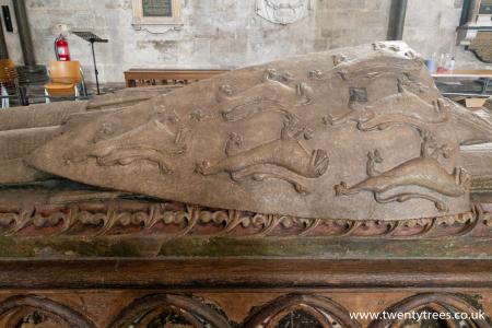
On 07 Mar 1226 William "Longsword" Longespee Earl Salisbury (age 50) was fatally poisoned by Hubert de Burgh Count Mortain 1st Earl Kent (age 56) at Old Sarum [Map]. Salisbury Cathedral [Map].


Pepy's Diary. 10 Jun 1668. Thence set out with a guide, who saw us to Newmarket-heath, and then left us, 3s. 6d. So all over the Plain by the sight of the steeple, the Plain high and low, to Salisbury, by night; but before I come to the town, I saw a great fortification, and there 'light, and to it and in it; and find it prodigious, so as to frighten me to be in it all alone at that time of night, it being dark. I understand, since, it to be that, that is called Old Sarum [Map]. Come to the George Inne [Map], where lay in a silk bed; and very good diet. To supper; then to bed.
The Port Way, Margary's RM4, starts in London and travels through Silchester Roman Fort [Map] aka Calleva Atrebatum, Old Sarum [Map], Badbury Rings [Map], Dorchester, Dorset [Map], Poole Harbour, Dorset [Map] to Exeter, Devon [Map].
The Wiltshire River Avon is formed from the confluence of the River Avon West, Wiltshire and River Avon East, Wiltshire one kilometre before Upavon, Wiltshire [Map] after which it flows broadly south past East Chisenbury, Wiltshire [Map], Enford, Wiltshire [Map], Fifield, Wiltshire [Map], Fittleton, Wiltshire [Map], Netheravon, Wiltshire [Map], Figheldean, Wiltshire [Map], Durrington Walls, around Amesbury, Wiltshire [Map] and past Amesbury Abbey, Wiltshire [Map], Wilsford, Wiltshire [Map], Great Durnford, Wiltshire [Map], Middle Woodford, Wiltshire [Map], Little Durnford, Wiltshire [Map], Old Sarum [Map], Stratford sub Castle, Wiltshire [Map], through Salisbury where it is joined by the River Nadder
After Salisbury the Wiltshire River Avon flows south in multiple channels past Longford Castle, Wiltshire [Map], after which it is joined by the River Eble, then Charlton-All-Saints, Wiltshire [Map], Downton, Wiltshire [Map], Breamore, Hampshire [Map], Burgate, Hampshire [Map], Fordingbridge, Hampshire [Map], Bickton, Hampshire [Map], Ibsley, Hampshire [Map], Ringwood, Hampshire [Map], Bistern, Hampshire [Map], Sopley, Hampshire [Map], Avon, Dorset [Map] and Christchurch, Dorset [Map] before reaching Christchurch Harbour where it joins the English Channel.
Europe, British Isles, South-West England, Wiltshire, Old Sarum, Hand Long Barrow [Map]
Hand Long Barrow is also in South England Neolithic Long Barrows.
Wiltshire Archaeological Magazine 1913 V38 Pages 379-414. Laverstock. 3. "Hand Barrow [Map]," about a mile N.E. of Old Sarum, ¾ mile N. of Ford, on the S. side of the Portway. Length 148ft.; N.N.E. and S.S. W. Nothing known of any opening. It is shown on Hoare's maps as two round barrows, but he speaks of it as "a tumulus called Hand Barrows, as if there were two mounds, but I am inclined to think they originally formed one long barrow." A. W. II. Roman Æra, 46. There are now dwarfish trees growing on the mound, but it is otherwise probably much in the same condition as when Hoare saw it. The ground round it is ploughed up to the edge of the mound, so that the ditches, if any, are entirely obliterated. A quantity of material has been taken away from the central part of the mound, giving somewhat the appearance of two distinct mounds, as at Corton Long Barrow (see under Boyton), but it is nowhere levelled down to the natural surface; material has also been taken from the larger end, leaving a hollow. In spite of these disfigurements, however, the mound still has decidedly the appearance of a "Long" barrow; it is considerably wider at one end than the other and tapers off regularly almost to a point. O.M. 66 N.E.; A. W. I. Station V., South, map only; II. Roman Æra 46.