Europe, British Isles, South-Central England, Oxfordshire, Little Rollright, Rollright Stones [Map]
Rollright Stones is in Little Rollright, Oxfordshire, Cotswolds Stone Circles.
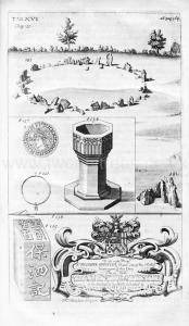
The Natural History of Oxfordshire Chapter 10. 81 Beside the Circles of Earth cast up by the Danes there are others of Stone in many places of this Nation and particularly one here in the very Bounds of OxfordShire near Chipping norton in the Parish of Little Rollwright the Stones [Rollright Stones [Map]] being placed in Manner and Form and now remain as exactly engraven Tab 15 Fig 2222 in a Round of twixt 30 and 40 Paces over the tallest of them all which may be a Scale for the rest being about seven Foot high North of these about a Bolts shoot off on the other side the Hedge in the County of Warwick stands one singly alone upwards of nine Foot high in Form as described Fig 1 and Eastward five others as in Fig 3 about two Furlongs off the highest of them all about nine Foot also meeting formerly at the Top (as drawn by Mr Camden) with their tapering Ends almost in Shape of a Wedge since whose time there are two of them fallen down from the rest of which ancient Monument or what ever else it be he gives us in brief this following account.
82 Not far from Burford (he should have said Chipping Norton for Burford cannot be less than 7 or 8 Miles from it) upon the very Border of Oxfordshire is an ancient Monument to wit certain huge Stones placed in a Circle the common People call them Rollrich stones and dream they were sometimes Men by a miraculous Metamorphosis turned into hard Stones The highest of them all which without the Circle looketh into the Earth they call the King because he should have been King of England (forfooth) if he had once feen Long Compton a little Town lying beneath and which one may see if he go fome few Paces forward.
83 Other five standing [Whispering Knights Burial Chamber [Map]] on the other side touching as it were one another they imagine to have been Knights mounted on Horseback and the rest of the Army. These would I verily think says he to have been the Monument of some Victory and happily errected by Rollo the Dane who afterwards conquer'd Normandy; for what time he with his Danes troubled England with Depredations we read that the Danes joined Battle with the English at Hochnorton a place for no one thing more famous in old time than for the woful Slaughter of the English in that foughten Field under the Reign of King Edward the elder.
84 That this Monument might be erected by Rollo the Dane or rather Norwegian perhaps may be true but by no means about the time of Edward the elders for though it be true enough that he troubled England with Depredations yet that he made them in the Days of King Alfred I think all the ancient Historians agree, An 897 according to Florilegus but according to Abbot Bromton a much better Author in the Year 875 near 40 Years before that Slaughter of the English in King Edward's Days as will plainly appear upon Comparison of this with the 75 of the same Chapter.
Avebury by William Stukeley. Roger Gale, "for Dr. Stukeley, to be left at the Grecian Coffee House in Devereux Court, near Temple Barr, London."— H. C. [This MS. Letter is in the possession of the Rev. H. F. St John].
Worcester, Augt 19, 1719.
Sir,
Last Saturday morning I had the satisfaction to see the stones called Rollrick [Map], which are but a molehill to a mountain in comparison of those we saw at Stonehenge and at Abury, and seem to have been intirely of another nature and design, as I doubt not but you will agree, upon my giving you the best description that I can of them. They are pitcht upon the top of a hill about half a mile south west of a village called Long Oompton, just within a hedge that now parts n ploughed field from a heath, and no doubt when these stones were placed there it was all heath. They compose a ring, not exactly circular8, the diameter of it from north to south being 35 yards9, and that from east to west but 33. The stones are of unequall dimensions both as to highth, breadth, and thicknesse, few of them exceeding 4 foot in altitude, and some of them reaching scarce two;10 and the breadth so various that I must have measured every stone to have given it you ; neither can I tell you the number, some being thrown down and broken, and others carryed away, but there are yet 22 standing11, and some of them pitcht so close together, edge by edge, that it is evident they were intended to form a close wall.12 The thicknesse of them is not above 14 or 16 inches. Where the entrance of it was is hard to say positively since there are many smooth gaps now in the ring, but as there is one directly north-east13 [King Stone [Map]] in a line to the King, as they call it, I am persuaded it was there. This King is a great stone which the countrey fancys represents a man on horseback, standing 84 yards14 N.E. of the circle, 8 foot high, 7 broad in the broadest part, and about 12 inches thick, and has, as appears by the gritt of the stone, been taken out of a quarry (as well as those atten- dants he has in the circle) within a hundred yards of his majesty, which observation of mine much displeased my landlord that came from Chipping Norton with me to show me this petrifyed court, which is the creed of the countrey , and he that contradicts it is lookt upon as most audacious free thinker.
I had like to have forgott observing that just in the north point of the circle is allso standing one stone much larger than the rest, being 7 foot high and 5i broad. I could observe no trench running round it, which, if there ever had been one, must still have shown itself upon the heath; nor any marks of an avenue leading to it, nor any barrows or tumuli within view of it, only a bank about 10 yards north of the King, in length about 20 yards, breadth 7, flatt and uneven on the top, as if made out of the rubbish of the neighbouring quarry.
The losse of your company in this journey I am every day more sensible of than the last, having many a heavy hour hang- ing upon my hands which your conversation would have made not onely to passe much easyer but profitably ; 6 long days more have I to lugg through in tiiis city, where the highest antiquity I can meet with rises no higher than the dusty traditionall tombs of a Saxon bishop or two. Which way I shall steer next I can- not determine yet, but if you will favour me with a line how matters go in both Societys, or with anything else you may think worth writing, by Satturday's post, it will be here on Monday morning ; if I cannot be so happy as to hear from you till after that time, be pleased to send your letter to my bouse, and it
will be forwarded thence to me. My service to all friends, and believe me, dear Sir,
Your most faithfull Friend, and humble Servant,
R. Gale.
P.S. In all probability it [the bank] is as ancient as the King himself, I mean cast up at the same time he was sett there, the countrey tradition joyning them together in a rhyme they all have.
If Long Compton thou canst see,
Then King of England thou shalt be.
You cannot see Long Compton where this King stands, but if you step a yard to the north of him it discovers itself over the top of this bank which intercepts it from his view.15
Note 8. Not far from being a true circle.
Note 9. The diameter from north to south is 101 feet, and not 105.
Note 10. The tallest stone is on the north boundary of the circle, and is 7 feet 4 inches high, and 8 feet wide at the gronnd IcTel ; scTen of the standing stones exceed 4 feet, aad one only ia less than 2 feet
Note 11. In 1S40, Sir Henry Dryden and the editor of these Diaries and Letters, made a careful ground plan of the circle, with elevations of the standing stones. At that date 22 stones were standing, the same number as stated by Roger Oale. About 80 were prostrate, and several must have been removed since 1719.
Note 12. Most probably this was the intention, for where two or more stones are still erect and near each other, they are as close as their irregular outlines will allow.
Note 13. There is no trace whatever of an avenue, or of any distinctly marked entrance.
Note 14. The distance from the drde to the king stone is 76 yards. The 9 feet 2 inches high, 6 feet wide at the ground level, and IS inches thick.
Note 15. This letter is referred to in Stukeley's Hist. of Abury, p. 11.
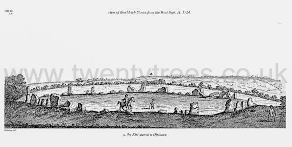
Avebury by William Stukeley. View of the Rowldrich Stones [Map] from the West Sep. 11. 1724. A. The Kistaven at a distance.
Avebury by William Stukeley. I shall begin with Rowlright [Map] or rather Rowldrich, and as a specimen of what requisites are sought for in these enquiries, I shall draw them up in a kind of order: which may be useful in all researches of this sort.
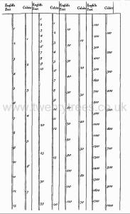
Avebury by William Stukeley. Of the origin of temples more particularly, the meaning of the name. The manner of them, round and open. The Mosaic tabernacle a temple square and covered, in opposition to the former desecrated into idolatry. Another reason, covered with skins, because typical of Messiah. So the patriarchal or Druid temples made in those forms, that were symbols of the deity, and the divine personalities thereof. When become idolatrous generally dedicated to the sun, by reason of their round form. The most ancient symbolic figure of the deity was the circle, snake and wings, which we see frequently on Egyptian and other Monuments. The patriarchal temples made in representations thereof; therefore of three kinds. I. A circle only. II. A circle and snake. III. A circle and wings. This Volume treats of a temple of each of these kinds in Britain. The temple of ROWLDRICH [Map] in Oxfordshire being of the first sort, described. The Evidence of its being a work of the Druids, drawn up in a kind of order, as a specimen. 1. Its high situation, on an open heath by the heads of rivers. 2. An open circle of stones set upright, taken from the surface of the ground. 3. The appearance of the weather on them. 4. From the name, the Gilgal of Joshua explained. 5. From the measure, the Druid cubit. 6. From the barrows all round it. A Druid's court. The king's tumulus. The archdruid's tumulus, the founder. 7. From old reports concerning these works. 8. Sepulchres frequently the occasion of founding temples in all ages, from a hope of the body's resurrection, and one occasion of deifying heroes, and introducing idolatry, the first species of it.
Avebury by William Stukeley. 1724. Table V. The prospect Northward from Rowldrich Stones [Map]. A. the King Stone [Map]. B. the Archdruids barrow. C. king barrows or round barrows. D. long compton.

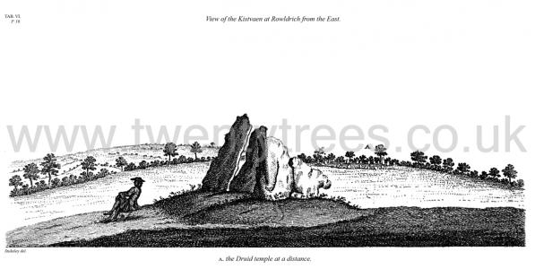
Avebury by William Stukeley. 1724. View of the Kistvaen at Rowldrich from the East. A. the Druid temple [Map] at a distance.
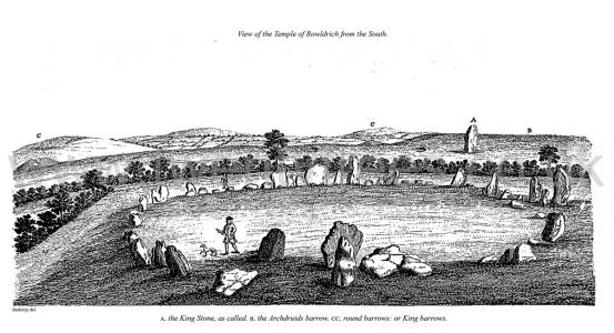
Avebury by William Stukeley. 1724. View of the Temple of Rowldrich [Map] from the South.
Avebury by William Stukeley. 1724. View of the Temple of Rowldrich [Map] from the South. A. the King Stone [Map] as called. B. the Archdruids barrow, CC rounds barrows or King barrows.
Paraochial History of Enstone. British And Roman Period 55 BC To AD 409. The great Roman emperor general and historian Julius Cæsar invaded Britain in the year 55 before the Christian era that is before the birth of Jesus Christ from whose birth we now reckon our years so that this is the year 1857 since He was born and is therefore called the year of our Lord or in Latin Anno Domini commonly written AD It is therefore now 1912 years since Britain was thus visited Some time however before this our country was known to the Romans by the name of Britannia but it was not discovered by them to be an island until the time when Agricola was governor and when he sailed round it The Romans continued to exercise dominion here for no less than 464 years that is from the year 55 BC till the year 409 AD It was during this period at least although very probably even before it that our most ancient monument the Enne Stan that is the Giant or Great Stone was erected for notwithstanding that that name is Saxon there can be no doubt of the monument so called being British or Romano British that is either founded in the most ancient times when Britons only knew and inhabited this island or during the period when the Romans reigned over the Britons and held them in subjection We can have little difficulty in conceiving what was the state and condition of this vicinity at that time It was like the uncleared forests of the United States of America or of Canada at this day or to come home to a nearer likeness still it was in much the same state as the yet disafforested remains of Wichwood now are. But with the exception of the surface of the earth and the single monument whence the parish now derives its name of Enstone no monument or memorial survives to tell us of the past and to point out to us where our British progenitors dwelt or lived. All that we know further is that in our immediate neighbourhood similar monuments to this have been erected and remain as the Hawk stone, or Hoar stone, at Dean the stone [Hoar Stone, Steeple Barton [Map]] at Barton and the very extensive and interesting British relics at Rollright commonly called the Rollright stones [Map]. It was at this period also that the tumuli to be found at Charlford must have been formed unless indeed they are to be regarded as of older date