South England West Burial Mounds
South England West Burial Mounds is in South England West, Neolithic Burials.
Europe, British Isles, South-West England, Cornwall, Zennor, Bosporthennis Quoit [Map]![]()
Nænia Cornubiæ by William Borlase Bosporthennis Cromlech. Bosporthennis Cromlech [Map].
There still remains, however, a fourth Cromlech in Zennor parish, the ruins of which are to be found in a small enclosure near the hamlet of Bosporthennis. It is situated in a marshy valley, running down to the sea at Polmear Cove, skirted on the western side by the picturesque granite peaks of Carn Galva. On the slope of this hill, and some four or five hundred yards from the Cromlech, are the ruins of hut circles, strewn in such numbers over the moor, that it is clear they represent the ground plan of a town of considerable size. One of these huts is, perhaps, the best specimen of the beehive type to be found anywhere in England, and in the style of its masonry presents the same megalithic construction which distinguishes the works of the Cromlech-builders. On the cliffs at Bosigran, about half-a-mile distant, are the remains of one of those "cliff castles" so common on the Cornish coasts, and which, doubtless, served in dangerous times as refuges for the persons and effects of the inhabitants of the surrounding villages.
Europe, British Isles, South-West England, Cornwall, Camborne, Carwynnen Quoit [Map]![]()
Celtic, Druidical and Roman Remains. The cover-stone of the Lanyon cromlech [Map] is 18½ feet long and 9 feet wide; from the under part of this stone to the ground it measures 5 feet. Borlase, and others who have followed him, state, that this cromlech is high enough for a man on horse back to pass under it. The Carwynen [Map] cromlech is less than that of Lanyon.
The Zennor cromlech is the largest in the county: the supporters are about 9 feet high, — the cover-stone, 18 feet long and 10½ feet wide.
Europe, British Isles, South-West England, Cornwall, Chûn Quoit [Map]![]()
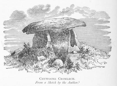
Nænia Cornubiæ by William Borlase Chywooner Cromlech. Chywoone Cromlech [Map].
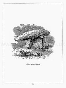
The most perfect and compact Cromlech in Cornwall is now to be described. It is situated on the high ground that extends in a northerly and westerly direction from the remarkable megalithic fortification of Chywoone or Chuun, in the parish of Morvah. The "Quoit" itself, which, seen from a distance, looks much like a mushroom, is distant just 260 paces from the gateway of the castle; and about the same distance on the other side of it, in the tenemerit of Keigwin, is a barrow containing a deep oblong Kist-Vaen, long since rifled, and now buried in furze. Thinking this monument the most worthy of a careful investigation of all the Cromlechs in the neighbourhood, the author proceeded to explore it in the summer of 1871, with a view to determine, if possible, the method and means of erection in the case of such structures in general.
Note 1. Footnote on image. There is a dolmen at Moytura, in Ireland, and another at Halskov, in Scandinavia, the drawings of which would both pass for Chywoone Cromlech.
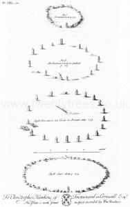
The Antiquities of Cornwall by William Borlase Chapter IX. In several parts of Cornwall we find a large flat Stone in a horizontal position (or near it) supportcd by other flat Stones fix'd on their edges, and fasten'd in the ground, on purpose to bear the weight of that Stone, which rests upon, and over-shadows them, and by reason of it's extended surface, and it's elevation of fix or eight feet, or more, from the ground makes the principal figure in tliis kind of Monument. The situation which is generally chosen for this Monument is the very summit of the hill, and nothing can be more exact than the placing some of them, which shews, that those who erected them were very sollicitous to place 'em as conspicuously as possible. Sometimes this flat Stone, and it's supporters, stand upon the plain natural soil, and common level of the ground; but at other times it is mounted on a Barrow made either of Stone or Earth; it is sometimes plac'd in the middle of a Circle of Stones-erect, and when it has a place of that dignity, must be suppos'd to be erected on some extraordinary occasion; but when a Circle has a tall Stone in the middle, it seems to have been unlawful to remove that middle Stone, and therefore we find this Monument of which we are speaking sometimes plac'd on the edge of a Circlec. But we find fome Cromlêhs erected on such rocky situations, and so distant from houses, (where no Stones-erect do stand, or appear to have flood,) that we may conclude, they were often erected in places where there were no such Circles. Some of these Monuments are quite inclos'd, and buried, as it were, in the Barrow; As that of Senor in Cornwall (Plate XVIII. Fig. iii.) and that at Chûn [Map] (Plate XX. Fig. x.) and that mention'd by Wormius, pag. 4. Mon. Dan.d
Note c. Sec Pl. XIII. Fig. iii. a, and b, in Boscawen-ûn [Map] from which we may draw this Consequence; that the Cromlêhs was posteriour in date to the Circle, and the former erected there for the sake of the latter.
Note d. One only which I have yet heard of, has it's Supporters, or Side-Stones, fix'd on a solid Rock. State of Downe, pag. 199.
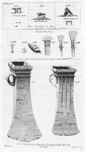
Celtic, Druidical and Roman Remains. The top-stone of Chûn cromlech [Map] is nearly 13 feet long and 11½ feet wide, — its elevation is about 4 feet.
Europe, British Isles, South-West England, Cornwall, St Columb Major, Devil's Quoit [Map]![]()
Nænia Cornubiæ by William Borlase Quoit near St Columb. Quoit Near St. Columb [Map].
The hamlet of Quoit, in the parish of St. Columb Major, is situated at the foot of the gradual acclivity crowned by the circumvallations of Castle-an-dinas, and derives its name from a Cromlech, which, until a year or two since, occupied the corner of a yard adjoining the high road. On the side opposite to Castle-an-dinas stretches away the Goss Moor, "a morisch ground," as Leland well called it, "al baren of woodde." The monument was extant in a dismantled condition until very lately; but a few rough spar stones, split up and ready to carry away, was all that remained of it when the author saw the place in July, 1871. Previous to its fall, it had been used as a goat's house; and, oddly enough, although penned up within it at the time of the collapse, Billy escaped perfectly unharmed.
Nænia Cornubiæ by William Borlase Quoit near St Columb. Old Hals mentions this Cromlech [Map] in his usual brief and inaccurate manner; but fortunately, Mr. Whitaker1 has left a much more full and detailed account. From him we learn that it was "formed of five stones, one covering, three supporting, and one buttressing." The area of the chamber "allowed three or four men to stand upright within it." The side stone on the north was "a spar exactly perpendicular, seven feet in height, and 4 feet 6 inches in width at the middle." That opposite to it, on the south side, was "an iron-stone 6 feet 11 inches high, and 3 feet 7 inches wide in the middle." The eastern slab was also an iron-stone, "7 feet 6 inches in tallness, and 3 feet 3 inches wide at the middle." The covering-stone was of the same nature as the two last, and "lies reclining" from the eastern one along the two others, the declivity being "19 degrees 40 minutes from east to west." "I mention these little circumstances," continues Mr. Whitaker, "to explain clearly a peculiar incident in the construction of the whole; the northern corner of the back-stone appears to have broken off under the weight of the top-stone, as the latter was laid or was settling upon the former; and the top stone now touches not the back-stone in that corner at all, resting only on the other, the southern corner. In consequence of the accident, the whole weight nearly of the top-stone was canted off upon the adjoining side-stone on the right or south; this finding that to press with a force which it was not calculated to bear, began to shrink from its original uprightness, and to lean considerably towards ' the north; it would have leaned very considerably if the eastern edge of it had not lapped over the southern of the back stone, there impinged strongly upon this in its inclination, and been stopped by the resistance which it thus encountered: even with that resistance, it has come to lean no less than 1 6 degrees 30 minutes to the north, or two feet out of the true perpendicular. The whole building, therefore, was in the most imminent hazard of being soon off its poise, and the supporting stones were likely to be crushed to the ground by the covering stone. To prevent this, with the same skill and boldness which could raise such masses upon such supporters; which could also calculate the duration of a structure so warping; and even rest secure enough in their calculations to work under the warping structure, a fifth stone was introduced into it, being thrust in behind the side-stone on the north, as a buttress to the northern edge of the back-stone. 1 A stone was hastily chosen, tapering upwards in form, but about six feet in tallness, a kind of bastard spar, having two legs, a long and a short one, to it; the long leg was pitched in the ground, while the short remains above ground useless; and the body of the stone was then fixed reclining in a sharp angle against the edge of the back-stone, so as to compose a rude kind of powerful arc-boutant to it. Thus buttressed, the back-stone has remained between the supporting and the pressing stones, without any inclination at all to the north; yet, with a projection to the west, the quarter on which it felt no resistance, of 7 degrees 30 minutes, or one foot from the perpendicular. Thus has the structure stood as firm as if no misfortune had befallen it."
Note 1. Cathedral of Cornwall, vol. ii. , p. 76.
Europe, British Isles, South-West England, Cornwall, Bosilack, Lanyon Quoit [Map]![]()
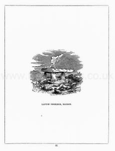
Lanyon Quoit [Map].
Llewellynn Jewitt 1870. Researches which have been made in recent times show the absurdity of all this, and prove beyond doubt that the cromlechs are neither more nor less than sepulchral chambers denuded of their mounds. In several instances they have been found intact, and, these mounds being excavated, have been brought to light in a perfect state. These instances have occurred in Cornwall, in Derbyshire, and in other districts of England, as well as in the Channel Islands and elsewhere. One instance is that of the Lanyon cromlech [Map] in Cornwall. It seems that some seventy years ago "the farmer" to whom the ground belonged cast a longing eye on what appeared to be an immense heap of rich mould, and he resolved to cart it away and spread it over his fields. Accordingly he commenced operations, his men day after day digging away at the mound, and carting the soil off to the fields. By the time some hundred cart loads or so had been removed the men came to a large stone, which defied their efforts at removal, and, not knowing what it might be, or what it might lead to, they went on removing the surrounding earth, and gradually cleared, on all its sides, the majestic cromlech which is now one of the prides of Cornwall.
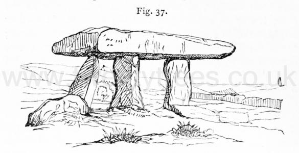
This highly interesting chamber contained a heap of broken urns and human bones. This "Lanyon cromlech," a view of which is given on fig. 37, consists now of three immense upright stones, on which rests an enormous capstone, measuring about eighteen and a half feet in length and about nine feet in width, and is computed to weigh above fifteen tons. How such stones were raised and placed on the rough upright stone supports which had been prepared for them is almost beyond comprehension, when it is recollected that they were raised by a people who were devoid of machinery.
"The heart,
Aching with thoughts of human littleness,
Asks, without hope of knowing, whose the strength
That poised thee here."
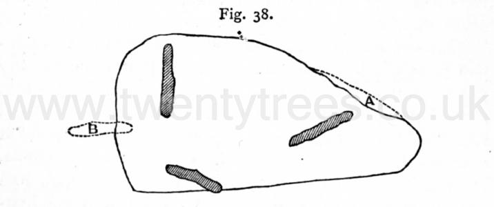
This cromlech when first uncovered consisted of four upright stones, on which rested the capstone. In 1815, during a tremendous storm, the capstone and one of the supports were thrown down. In 1824 the capstone was replaced, under the superintendence of Lieut. Goldsmith, R.N., and at this time a piece was broken off at A. The fourth upright stone was not replaced, having been broken when thrown down. Fig. 37 shows the cromlech as replaced. Fig. 38 is a plan of it, showing the uprights and the capstone. The large outline is the capstone, the part marked A being the part broken off; the shaded parts are the present three uprights; and B the fourth upright, broken.
Nænia Cornubiæ by William Borlase Lanyon Cromlech. LANYON CROMLECH [Map]
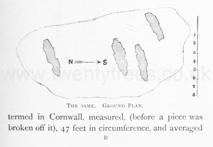
This monument, as will be seen from the accompanying engraving taken from Borlase's Cornwall2, consisted, until its fall in the year 1815, of three slim pillars of unhewn granite, supporting on their summits a horizontal stone, at a sufficient height from the ground to permit a man mounted on horseback to sit under it. The cap stone, or "quoit," as it is termed in Cornwall, measured, (before a piece was broken off it), 47 feet in circumference, and averaged 20 inches thick. Viewed from the opposite hill, for it stands on high ground, the whole structure may not, even in its present stunted form1, be inaptly compared to a three-legged milking-stool. About the middle of the last century, a dream induced the owner of the property to dig beneath it, and directly under the "quoit" a simple grave was discovered, cut in the natural soil, without side stones or covering. At the depth of six feet the explorers reached the bottom; but unfortunately the other dimensions are not recorded. Although this pit was carefully searched on that occasion, and subsequently rifled more than once, Dr. Borlase assures us that nothing was found "more than ordinary." From this discovery, it seems quite clear that inhumation was the mode of burial practised in this case; for had cremation taken place, ashes, or at all events strata of burnt earth, would have been found; and it is only on the supposition that the corpse was laid unprotected in the porous ground, without any imperishable articles accompanying it, that the total absence of relics in the grave can be at all accounted for. Had the length of the cavity been recorded, some inference might have been formed as to the position in which the body was placed; that is whether it was extended at full length, or contracted, with the knees bent up towards the chin. Trivial as such a distinction may at first sight appear, it is just one of those points which, if carefully followed up, may one day become valuable to the ethnologist in distinguishing the lines of demarcation to be drawn between the various races or tribes inhabiting this country in the primitive era.
Note 2. The accuracy of the dimensions given in Borlase is fully borne out by a drawing of the same monument made by the late Canon Rogers, in 1797, eighteen years before its fall.
Note 1a. It was set up again in 1824, but several of the stones had been broken, and one of the supporters bears marks of recent cleavage. At present a person must stoop to pass under it.
Nænia Cornubiæ by William Borlase Lanyon Cromlech. Two monuments of this kind are extant in Cornwall. They are situated within a mile or two of each other, and of the Lanyon Cromlech [Map], and both have been explored, the first by Dr. Borlase in the year 1752, and the second by the author in 1871.
Celtic, Druidical and Roman Remains. There are five of these ancient monuments in the west of Cornwall, all in a good state of preservation. The remains of one may be seen in a field about half-a-mile from the Lanyon cromlech [Map], and of another at Bosprennis, in Zennor [Map]. There are two other cromlechs beyond the limits of our inquiries, - one at Trevethy [Map], in St. Cleer, and another, now fallen, at Coit, in St. Columb.
Celtic, Druidical and Roman Remains. The cover-stone of the Lanyon cromlech [Map] is 18½ feet long and 9 feet wide; from the under part of this stone to the ground it measures 5 feet. Borlase, and others who have followed him, state, that this cromlech is high enough for a man on horse back to pass under it. The Carwynen [Map] cromlech is less than that of Lanyon.
The Zennor cromlech is the largest in the county: the supporters are about 9 feet high, — the cover-stone, 18 feet long and 10½ feet wide.


Europe, British Isles, South-West England, Cornwall, Mulfra Quoit [Map]![]()
Nænia Cornubiæ by William Borlase Mulfra Cromlech. Mulfra Cromlech [Map].
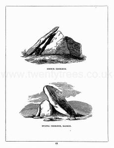
This monument consists at present of three granite slabs five feet in height, forming the west, north, and east sides of a kist 6 feet 8 inches long, i.e., from east to west, and four feet wide from north to south. On the southern side, instead of the fourth slab, a stone, which is supposed to have been once he covering-stone, rests lengthways and obliquely against the edges of the side stones. This stone, the lower end of which is now fixed in the ground, measured, with "a piece evidently clove or broke off from it," in Borlase's time, 14 feet 3 inches long, by 9 feet 8 inches broad. At that time a stone-barrow, now entirely removed, measuring two feet high, and thirty-seven in diameter, surrounded the monument. There is little doubt that the removal of the southern supporter caused the overthrow of Mulfra Quoit. It might indeed be possible that the cap-stone was never actually raised to the position for which it was intended; but the fact of a fracture having taken place in it, as well as the angle at which it now stands, which is precisely that it would have assumed had it been overbalanced and slipped from its place, presents no analogy to the case of Lower Lanyon, and confirms the supposition that it is simply a fallen Cromlech. The author of the Land's End District states that, he was informed that the date of its collapse was 1752, during a thunderstorm. He was, however, probably misled by an account published in the Philosophical Transactions of the year following, in which it is recorded that a "quoit" on Molfra Hill, (meaning the highest stone on a natural pile of rocks, and often so called by the Cornish), had been struck by lightning in that year. Dr. Borlase visited the spot on the 23rd of October, 1 749, and at that time the Cromlech was in precisely the same state as at present. He says, "As this Quoit is off from its ancient situation with one edge resting on the ground, I thought it might permit us safely to search the enclosed area." Nothing of importance was discovered, and the Doctor only found that a pit had been sunk twenty inches deep in the area of the Kist-Vaen, and "that something which either was originally, or has since turned black, was placed in the bottom of it."
Celtic, Druidical and Roman Remains. The cover-stone of Mulfra [Map] is about 9 feet by 12 feet. The upright stones are 5 feet high.

Europe, British Isles, South-West England, Cornwall, St Breock, Pawton Quoit [Map]![]()
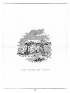
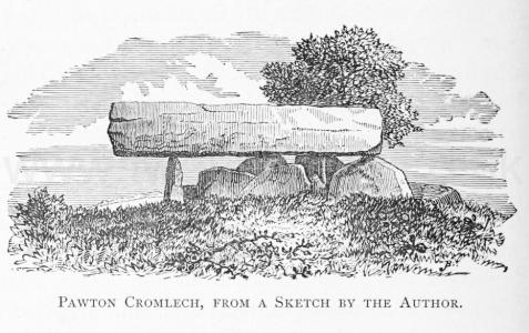
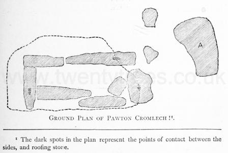
Nænia Cornubiæ by William Borlase Caerwynen Cromlech. This monument [Pawton Quoit [Map]] is situated on high ground in the centre of a field immediately above the picturesque valley and ancient ecclesiastical establishment of Pawton.
The accompanying sketch, taken by the author a few months since, will, perhaps, convey some slight idea of the structure. The stones which form the grave are eight in number, but the covering stone itself rests on only three of them. They are still more than half buried in the tumulus which formerly, no doubt, covered the whole. This was of an oval shape, and upwards of sixty feet in length. The grave itself is seven feet long; and, but for a stone which has been inserted at one end, would be a foot and a half longer. This stone is probably a prop to support the one on which that end of the capstone rests. The width of the grave is two feet at one end, and three and a half at the other: it is at present five feet deep, though it may in all probability be several feet deeper. The sparry stone which forms the covering is thirteen feet in length, by seven in breadth; and, as a labourer informed me that a piece (marked A, in the accompanying plan,) had been broken off from it, the length may be increased by several feet. In thickness the covering stone is uniformly two feet six.
From the shape and size of the kist in this case, there can be no doubt that it was constructed to contain a body at full length; and although, as was before noticed, interments in that position are so very rare in other parts of England, there are other instances (though few and far between) of similar graves in Cornwall, to prove that this mode of burial was not by any means unknown in that district. In several cases the author has particularly noticed that the grave is too narrow to admit of the body being contracted at all, and in more than one case a skeleton 1 extended has actually been found. Two or three of these long walled graves may here be described.
Europe, British Isles, South-West England, Cornwall, Bosilack, West aka Lower Lanyon Quoit [Map]![]()
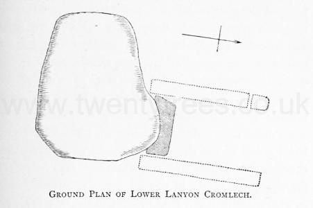
Nænia Cornubiæ by William Borlase Lower Lanyon Cromlech. Lower Lanyon Cromlech [Map].
The monument referred to is, curiously enough, situated on the same estate as the one lately described, namely, at Lanyon, in the parish of Madron; and is quite as good a specimen of the "Kist" type, as the former one was of the "Cromlech proper."
Two stones are all that now remain, viz., the covering stone, and one of the supporters; the others having been split up and carried away for building. A very rough sketch of this Cromlech, when perfect, will be found in Mr. Cotton's Illustrations of Antiquities in Cornwall, page 37; and the following notice of its discovery is preserved in the Archæologia, Vol. xiv, page 228.
"The gentleman who owns the estate of Lanyon, happening to be overtaken by a shower of rain in walking through his fields, took shelter behind a bank of earth and stones, and remarking that the earth was rich, he thought it might be useful for a compost. Accordingly, he sent his servants soon after to carry it off, when, having removed near a hundred cart loads, they observed the supporters of a Cromleh, from which the coverstone was slipped off on the south side, but still leaning against them. These supporters include a rectangular space open only at the north end, their dimensions being of a very extraordinary size, viz., that forming the eastern side ten feet and a half long, that on the west nine feet, with a small one added to complete the length of the other side, and the stone shutting up the south end about five feet wide. The cover-stone is about thirteen feet and a half, by ten feet and a half." "As soon as the gentleman observed it to be a Cromleh, he ordered his men to dig under it, where they soon ound a broken urn with many ashes, and going deeper they took up about half of a skull, the thigh bones, and most of the other bones of a human body, lying in a promiscuous state, and in such a disordered manner as fully proved that the grave had been opened before; and this is the more certain, because the flat stones which formed the grave, or what Dr. Borlase calls the Kist Vaen, and a flat stone, about six feet long, which probably lay at the bottom, had all been removed out of their places." The measurements of the covering stone given in this account quite accord with those taken by the author a short time since. In thickness it averages from one foot six, to one foot nine inches. It may be reasonably doubted if, from its present position, this stone was ever raised to the place for which it had been intended. Had such been the case, the mound would no doubt have served to consolidate the whole fabric, and to keep it in its place; and its present appearance leads to the conclusion that the builders, in this case, were never able to complete the stupendous work which they had begun. One of the displaced stones mentioned above may, perhaps, have served as the covering stone of the interment, in the absence of the one designed for that purpose.
The accompanying plan is an attempted restoration of this Cromlech (ist) from the stones as they now stand, (2nd) from the drawing by Mr. Colton, and (3rd) from the above account.
Europe, British Isles, South-West England, Cornwall, Zennor Quoit [Map]![]()
Nænia Cornubiæ by William Borlase Zennor Cromlech. Zennor Cromlech [Map].
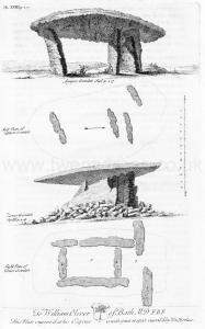
Zennor Quoit, as the Cromlech in the parish of that name is usually called, was, when Borlase wrote his History, the most interesting and perfect specimen of a Kist-Vaen in Western Cornwall. In all probability it had been freshly disinterred from its cairn, or rather the gigantic structure had just succeeded in shaking off, or piercing up through, the crust of loose debris which had been piled over it; for in the middle of the last century, "a stone barrow, fourteen yards in diameter, was heaped round it, and almost reached to the edge of the Quoit."1 Care had been taken, however, in its erection, that no stone should get into the chamber, and it was with great difficulty that a man could squeeze himself into it. Since then, progress and destruction, working together as usual, have much impaired the monu- ment; the cap-stone has been rolled off, and the other stones otherwise damaged by being made to serve as the supports of a cart-shed. Fortunately an original drawing and a plan were made for Dr. Borlase's work, and these the author has been able to reproduce in woodcut from copies of the identical copper-plates then used. They will be found much more accurate and valuable than any sketch of the ruin, as it is at present, could possibly be.
Note 1. The word "Quoit" is here used for the cap-stone only.
The Antiquities of Cornwall by William Borlase Chapter IX. In several parts of Cornwall we find a large flat Stone in a horizontal position (or near it) supportcd by other flat Stones fix'd on their edges, and fasten'd in the ground, on purpose to bear the weight of that Stone, which rests upon, and over-shadows them, and by reason of it's extended surface, and it's elevation of fix or eight feet, or more, from the ground makes the principal figure in tliis kind of Monument. The situation which is generally chosen for this Monument is the very summit of the hill, and nothing can be more exact than the placing some of them, which shews, that those who erected them were very sollicitous to place 'em as conspicuously as possible. Sometimes this flat Stone, and it's supporters, stand upon the plain natural soil, and common level of the ground; but at other times it is mounted on a Barrow made either of Stone or Earth; it is sometimes plac'd in the middle of a Circle of Stones-erect, and when it has a place of that dignity, must be suppos'd to be erected on some extraordinary occasion; but when a Circle has a tall Stone in the middle, it seems to have been unlawful to remove that middle Stone, and therefore we find this Monument of which we are speaking sometimes plac'd on the edge of a Circlec. But we find fome Cromlêhs erected on such rocky situations, and so distant from houses, (where no Stones-erect do stand, or appear to have flood,) that we may conclude, they were often erected in places where there were no such Circles. Some of these Monuments are quite inclos'd, and buried, as it were, in the Barrow; As that of Senor in Cornwall (Plate XVIII. Fig. iii.) and that at Chûn [Map] (Plate XX. Fig. x.) and that mention'd by Wormius, pag. 4. Mon. Dan.d
Note c. Sec Pl. XIII. Fig. iii. a, and b, in Boscawen-ûn [Map] from which we may draw this Consequence; that the Cromlêhs was posteriour in date to the Circle, and the former erected there for the sake of the latter.
Note d. One only which I have yet heard of, has it's Supporters, or Side-Stones, fix'd on a solid Rock. State of Downe, pag. 199.


Celtic, Druidical and Roman Remains. There are five of these ancient monuments in the west of Cornwall, all in a good state of preservation. The remains of one may be seen in a field about half-a-mile from the Lanyon cromlech [Map], and of another at Bosprennis, in Zennor [Map]. There are two other cromlechs beyond the limits of our inquiries, - one at Trevethy [Map], in St. Cleer, and another, now fallen, at Coit, in St. Columb.
