Text this colour links to Pages. Text this colour links to Family Trees. Text this colour are links that are disabled for Guests.
Place the mouse over images to see a larger image. Click on paintings to see the painter's Biography Page. Mouse over links for a preview. Move the mouse off the painting or link to close the popup.
Archaeologia Cambrensis 1931 Volume 81 Pages 1-35 is in Archaeologia Cambrensis 1931 Volume 81.
A Bronze Age Barrow [Map] On Kilpaison Burrows, Rhoscrowther, Pembrokeshire. By Cyril Fox, PH.D., F.S.A.
The peninsula whereon the town of Pembroke is situated, which presents at its most southerly point the well-known sea-mark of St. Gowan's Head, consists of a ridge of Old Red Sandstone rising to a height of over 200 ft., the main axis of which runs east-south-east and west-north-west.
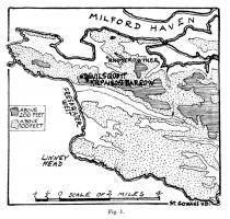
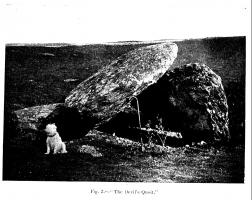
South-west of Rhoscrowther village the peninsula is little more than one mile in breadth, and from the ridge hereabouts a fine view is obtained; on the one side the open sea, on the other the beautiful estuary of Milford Haven. From the wide sandy beach of Freshwater West, 200 ft. below, the south-westerly gales have driven masses of sand on to the very crest of the ridge; the area thus enveloped is known as Kilpaison Burrows (Fig. 1). The plateau was probably free from these accumulations in prehistoric times. The Devil's Quoit [Map], a well-known dolmen (Fig. 2), is on the margin of the sand-covered area, and deep within it, 420 yards south-east of the dolmen, is the Bronze Age barrow now to be described1.
Note 1. See Pemb. 6-in. 0.8. Sheet XXXIX S.W. The Devil's Quoit is marked on this map.


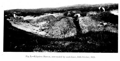
An amphitheatral-like area had been blown clear of sand, and a low mound of earth thus exposed on which fragments of pottery were visible attracted the attention of the Rev. J. P. Gordon Williams. In July, 1925, this barrow was excavated by Messrs. A. G. O. Mathias and J. D. Beddoe, of Pembroke (Fig. 3). It contained primary and secondary interments by cremation, and one secondary inhumation burial. The site was visited on two occasions by representatives of the National Museum of Wales, and the urns, one of which is perfect, and the others fragmentary, have been presented by Mr. Mathias1 who gave every facility for the independent investigation of the character and history of this very remarkable burial mound.
Note 1. Fragments of one additional urn, found by Mr. Gordon Williams, have be:n presented to the Museum through the kind offices of the Carmarthenshire Antiquarian Society, in order that the entire collection may be exhibited together.
The account which follows is compiled from information very kindly supplied by Messrs. Mathias and Beddoe, and from personal examination of the mound. The barrow was circular, and just over four feet in height at the centre. There was no visible trace of a ditch. It was composed of reddish clayey earth, without admixture of stones. Similar soil was obtainable, we were informed, a quarter of a mile away; but it is probable that when the plateau was clear of sand it could have been dug in the immediate neighbourhood.
The Primary Burial
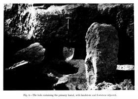
Approximately in the centre of the mound was an upright monolith of the local conglomerate, its base sunk 1 ft. 3 in. below the original ground level. Stones of moderate size were piled round it, but not to the top. Its dimensions were: height (above ground), 3 ft. 11 in.; breadth, 2 ft. 4 in.; width, 10 in. Almost due south of this monolith, there was a much smaller mass of the same stone (2 ft. 7 in. in greatest diameter) which lay on the original surface of the ground; the interval between the stones was four feet1.
Note 1. It has been shifted a foot or so to the east by the diggers. Replaced in the position in which it was found the measurements are as represented.
Halfway between them a circular basin-shaped hole had been made in the ground. It was 1 ft. 5 in. deep and the same in diameter, very smoothly and carefully hollowed. Its walls were blackened with charcoal and i ine a deposit of burnt bones—the primary burial.
The deposit was submitted to Sir Arthur Keith, who kindly sent the following report: "I can recognize nothing among the burnt bones except human remains ~~ —apparently of one individual. The skull bones are remarkably thin and the sutures unclosed: no fragment suggests a big bone: I infer the person cremated was a young woman—but the evidence is not at all decisive."

The symmetrical disposition of these stones in relation to the burial left no doubt in the mind of an observer that they were intimately connected with it, and that the whole must have formed a dignified and impressive setting to the ritual of interment1. One was instantly reminded of the headstone and footstone commonly employed in Christian burial in this country from the VII century onwards: the setting of the broad face of the larger stone at right angles to the alignment of the monument intensified the resemblance (see Fig. 4).
Note 1. It was, however, thought. desirable to examine the subsoil below the monolith to make sure that this did not cover a cist-burial. Excavation was also undertaken to see whether the smaller stone was one of a circle round the monolith. In both cases negative results were obtained.
That these stones were not permanently visible memorials may be taken as certain. Charcoal (traces of the funeral pyre?) lay here and there close to the burial on the original surface of the ground1. The smaller stone was merely laid on the ground, and could easily have been displaced: had the memorial been permanently visible, we may be sure that this stone would have been firmly set.
Note 1. It would have been carried to a depth of six inches or more by the action of earthworms had the surface been exposed subsequent to deposit.
When the ceremonies connected with the burial were completed, the barrow as we now see it was erected. Its crest before excavation just covered the top of the headstone. No line of stratification indicative of later additions was detected in any of the sections exposed.
Burials at the foot of megaliths, by inhumation or cremation, are not unknown in Western Europe. Anderson1 illustrates inhumation and cremation burials of the Bronze Age at the bases of menhirs forming circles at Tuack and Crichie, Aberdeenshire1. Cremation burials have been found at the foot of menhirs in Southern Finistére3 and a skeleton under a menhir in the Department of Seine et Marne4. Partly buried in a mound at Er Manieu, Kermario, near Carnac, was a menhir, at the foot of which were found small axes in diorite and fibrolite and a tomb-like construction5.
Note 1. Scotland in Pagan Times, Bronze and Stone Ages, Figs. 119, 121, 129.
Note 2. A discovery which, though not strictly parallel, is of interest in this connexion, is that of a beaker burial at the foot of the Long Stone, Avebury, one of a group of three stones forming a "cove or cell." Wilts. Arch. May., 38, 1.
Note 3. Du Chatellier, Les Epoques Préhistoriques et Gauloises dans le Funastére, 1889, 26.
Note 4. Op. cit., 26.
Note 5. Z. le Rouzic, Carnac: Fouilles faites dans la Région, 1923, esp. Figs. 57-69.