Text this colour is a link for Members only. Support us by becoming a Member for only £3 a month by joining our 'Buy Me A Coffee page'; Membership gives you access to all content and removes ads.
Text this colour links to Pages. Text this colour links to Family Trees. Place the mouse over images to see a larger image. Click on paintings to see the painter's Biography Page. Mouse over links for a preview. Move the mouse off the painting or link to close the popup.
The History of Banbury by Alfred Beesley is in Prehistory.
BRITISH AND ROMAN PERIOD.
The Dobuni.
Duriug the early British period, before the Roman mvasiou, the northern parts of Oxfordsliire and great part of Gloucestershire were peopled by the tribe whom Ptolemy calls Δοβουνοι (Dobuni), and Dion Cassius Βοδουνοι (Boduni). The particular tract is described by some writers as probably extending, on the west, to the hills bordering upon the Severn ; and on the south, as far as the hill of Wotton under Edge in Gloucestershire and the banks of the Isis and Thame in Oxfordshire. The possessions of the Dobuni appear to have been bounded northward by the chain of hills extending along the northern Hmits of Oxfordshire, and now marking the general boundary between the table land of that county and the deep Vale of Warwickshire. (See the Map, Plate 4.) On the southeast the limit was probably the natural barrier of hills on the Buckinghamshire side of the Thame. The neighbouring tribes, on this northeastern border of the Dobunian territory, were the Carnabii in Warwickshire and the northwest ; the Coritani in Northamptonshire and the northeast ; and the Cassii or Cattieuchlani on the east, in Buckinghamshire, Bedfordshire, and Hertfordshire.8
Note 8. Camden; Kennet's Paroch. Antiq.; MS. Hist. Alchester, 1622, piinted iu Keniict Brewer's Oxf.
Corinium9 (Cirencester) is mentioned as the chief town or place of resort of the Dobuni ; and Alauna10 (supposed,11 though without any grounds of evidence for the supposition, to have been Alchester, in the parish of Wendlebury, one mile and a half S.S.W. from Bicester) was another station within their territory. There are traces of several British settlements and fortifications in the neighbourhood of Banbury.
Note 9. Ptolemy, Geog. lib. ii. p. 37.
Note 10. Richard of Cirencester, edit. 1809, pp. (35), 46.
Note 11. Stukeley's Itin. Curios.; Brewer's Oxf.
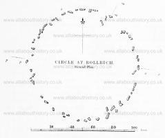
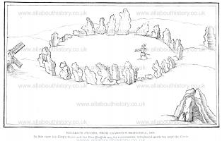
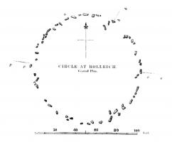
The most interesting remain of this period within the territory of the Dobuni, or indeed any where in the central part of the island, is the Druidical Temple at ROLLRICH [Map]. These stones are eleven miles southwest from Banbury, on the top of the range of liills just mentioned, which murks the bomidary between the table hmd of these parts of Oxfordshire and the great Vale of Warwickshire, and formed the extreme frontier of the territory of the Dobuni towards that of the Carnabii. The principal stones form a circle, the diameter of which from north to south is 107 feet, and that from east to west 104 feet. The area is now planted with fir trees, which it has been found necessary to omit in the sketch given in Plate 1. The original number of stones in this Circle appears to have been about sixty. This very nearly corresponds with the present number, but from mutilations and the effects of time many of the stones are now almost levelled with the ground.12 There are at present only twenty-eight which rise more than one foot above the soil ; and of these only ten exceed four feet in height. The highest stone (which is marked (a) in the ground plan above) stands 23° west of the north point of the area, and is seven feet four inches in height and three feet two inches in breadth. The thickness of the stones is generally not more than fifteen inches. The best representation of them in a state less imperfect than that in which they now are, is a print in the folio edition of Camden's Britannia printed in 1607, stated by him to have been done "iam olim" (a long time, or good while, ago).
Note 12. Dr. Stukeley graphically describes the Rollrich Stones as being "corroded like worm-eaten wood, by the harsh jaws of time, and that much more than Stonehcnge." Stukeley's Abury, V. 2, p. 10.


Opposite to the highest stone, at the part of the circle between south and southeast, are the remains of some large stones which were originally set together in that part just within the circle. The entrance seems to have been on the northeast, nearly in the direction of the King's Stone. This stone is 83 yards distant from the outer edge of the Circle, in the direction marked (b — h) in the ground plan, and is now (after considerable mutilations) eight feet six inches in height and five feet three inches in breadth. Such large stones placed singly in the vicinity of Druidical temples have been by some imagined to have served as pedestals for idols.

About 390 yards nearly due east of the Circle (in the direction c — c) are five large stones called the Five Whispering Knights [Map], which stand together, leaning towards each other, with an opening from the west. (See Plate I, and the Ground Plan at p. 5.) The tallest of these is now ten feet ten inches in height. They are most probably the remains of a Cromlech, or altar for the idolatrous sacrifices; but the upper or table stone has fallen or been removed.13 On the opposite side of the Circle to that occupied by the Knights, (in the direction d — d,) a large stone once stood on a bank or hill, 141 yards westward from the circle.14
Note 13. The tradition of the neighbourhood is that a farmer once carried away one of the large Rolhich stones to make a bridge, but that experiencing remorse he brought it back again. Dr. Stukeley says of Rolh-ich, more than a century ago, "Many of the Stones have been carried away within memory, to make bridges, houses, &c." — Stukeley's Abury, v. 2, p. 10.
Note 14. See a ground plan &c. among Mr. Gough's collections in the Bodleian Library, where this stone is described as having been long thrown down.
Dr. Stukeley derives the name of Rollrich from Rholdrwyg, the Wheel or Circle of the Druids ; or from Roilig, in the old Irish, signifying the Church of the Druids.15 In the seventeenth century Ralph Sheldon Esq. caused the area of the Circle to be dug up to a considerable depth, but no remains of any description were discovered.16 A sacrificial celt17 found in the parish of Long Compton, immediately below Rollrich, is in the possession of M. H. Bloxam Esq. of Rugby. It is of white flint, perfectly smooth, and of an oval form, with the sides flattened.
Note 15. Abury.
Note 16. Gibson's Camden.
Note 17. Celt. Sec note in the section on the Portway.

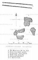
At Enstone, six miles and a half S.E. from Rollrich, is another Druidical remain, a ruined Cromlech, popularly called the "Hoarstone [Map]."18 The principal stone stands upright, and measures nine feet five inches in height, six feet seven inches in breadth, and three feet five inches in thickness. Two stones of inferior height, on the north side, incline towards the principal stone, leaving an opening of three feet five inches towards the east, in which direction, at six feet distance, a large stone lies imbedded. On the side N.E. from the three standing stones, lies a huge flat stone, measuring eight feet five inches by eight feet one inch, which was probably the table stone of the Cromlech. There is a tradition that a city once existed near this spot, and remains of wells have been found in the neighbouring fields.19 An ancient trackway, marked in some old maps as the "London Road" (comnunicating with the country about Worcester and Hereford), runs westward from the Hoar stone, passing near several Tumuli which will be mentioned hereafter. Nearly a mile south from this trackway, and two miles and a half westward from the Hoarstone, is a large single stone, seven . feet five inches high, called the "Hawkstone."
Note 18. The name Hoarstone implies a horckr or boundary stone. Such appear to have been erected from the earliest times. See Josh. xv. 6.—" And the border went up to the stone of Bohan the son of Reuben." A stone on the borders of Warwickshire having the same name of Horestone is mentioned hereafter.
Note 19. Information from the Rev. E. Marshall of Enstone.