Text this colour is a link for Members only. Support us by becoming a Member for only £3 a month by joining our 'Buy Me A Coffee page'; Membership gives you access to all content and removes ads.
Text this colour links to Pages. Text this colour links to Family Trees. Place the mouse over images to see a larger image. Click on paintings to see the painter's Biography Page. Mouse over links for a preview. Move the mouse off the painting or link to close the popup.
Drewsteighton Cromlech aka Spinsters' Rock, Devon is in Drewsteignton, Devon, South England Neolithic Long Barrows.
Drewsteighton Cromlech aka Spinsters' Rock, Devon [Map] is a Neolithic dolmen near Drewsteignton in Devon. It is situated on Shilstone Farm west of the village.
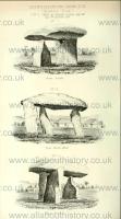
Historical Views of Devonshire Volume 1. The only Cromlech [Drewsteighton Cromlech aka Spinsters' Rock, Devon [Map]] in this county (which is indisputably such) is situated in Drewsteigton (the town the Druids upon the the Teign) on a farm called Shilston, in ancient deeds Shilsestan signifies the shelf-stone or shelving-stonea. Cromlech, it would be abfurd to conjecture. It is, at present, known in the neighbourhood, by the name of the Spinster's-rock. This Cromlech is of moor-stone: And Mr. Chappie informs us, "that like most others, it has only three supporters; flat, and irregular in their shape; their surfaces rough and unpolishe'd; and their position not directly upright but more or less leaning, (two to the northward, and the other to the south and east), and yet so as firmly to sustain the very ponderous table-stone which covers them. The whole forming a kind of large irregular tripod, and of such a height as if designed for the seat to the queen of Brobdingnag's dwarf, or the footstool of Gulliver's nurse; its upper surface being, where highest, near 9 feet and half from the ground, and the whole on an average at least 8 feet. The greatest length of its table-stone between its two most distant angles is about 15 feet, but taken parallel to its sides about 14, and at a medium not above 13 feet and half; its greatest breadth 10 feet, but this measur'd at right angles in that part where its two opposite sides are nearly parallel, is at a medium but 9 feet 10 inches.
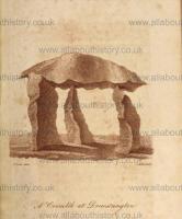
Essays by a Society of Gentlemen at Exeter 1796 Pages 106-129. The cromlech [Drewsteighton Cromlech aka Spinsters' Rock, Devon [Map]] is the most considerable monument of any that now remain . The only one in the county is situate on a farm called Shel-stone, in the parish of Drewsteignton (so named, I should conceive, not from the Norman Drogo, as Risdon hath asserted,) but from this and other relics therein remaining, appropriated to the Druids, simply deriving its appellation from the residence of the Druids on the river Teign . The Cromlech here, is perhaps the most perfect in the kingdom . The covering stone or quoit hath three supporters; it rests on the pointed tops of the southern and western ones, but that on the north fide upholds it on its inner inclining surface somewhat below the top, its exterior sides rising several inches higher than the part on which the super-incumbent stone is laid . This latter supporter is seven feet high - indeed they are all of such an altitude, that I had not the least difficulty in passing under the impost erect, and with my hat on; the height, therefore, of the inclosed area, is at least six feet . Of the quoit I made a measurement, and found the dimensions to be, from the north to the southern edge, 14 feet and half; and from the east and west it was of similar length . These edges or angles seeming to present themselves (as far as I could make an observation from the sun,) exactly to the cardinal points . The width across was ten feet . The form of this stone was oblate, not gibbous, but rounding from the under face, rising from the north about 13 inches higher than in the other parts; yet so plane on its superficies, that I could stand on it, or traverse it without apprehension of danger . That the Cromlech was a monument of the Britons, there can be no doubt; but that it was a Druidical altar, and of old, applied to sacrificial uses, cannot now be ascertained . Borlace and others who have treated this subject, judge the species of monument to have been sepulchral; and there is reason for the supposition, since they are often found erected on barrows, which are avowedly sepulchral . Indeed, in Ireland, the matter hath been sufficiently elucidated; for bones have been absolutely found in the area which some of them inclosed . Though Borlase, therefore, failed in Cornwall, it rests on more than probability, that, to whatever other purposes it might have been applied the use and intent of the Cromlech, that is, the crooked (or as some interpret the word, consecrated stone,) was primarily to distinguish and do honor to the dead; and at the same time to inclose the venerated reliquiæ, by placing the supporters and covering stone in such a manner as to be a security to them on every side .
![]() Become a Member via our 'Buy Me a Coffee' page to read complete text.
Become a Member via our 'Buy Me a Coffee' page to read complete text.
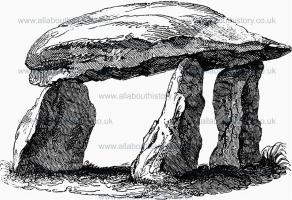
Magna Britannia Volume 4. 1807 The cromlech [Drewsteighton Cromlech aka Spinsters' Rock, Devon [Map]] at Drewe's Teignton, of which much has been said and written, has been supposed by some to have been the sepulchre of an arch-druid: that it was sepulchral there is little doubt; and from the rarity of such monuments, it is most probable that it was for some eminent person; but there is no more reason for supposing that it had any thing to do with druidism, than that the name of Drewe's Teignton was derived from that source.1 This cromlech is on a tenement called Shilston. It is of moor-stone, about 12 feet in length, and about nine feet wide in the widest part. The supporting stones are from six feet to six feet and a half to the under part of the covering stone.
The sketch beneath is from an accurate drawing, made by my brother, in 1807.
Note 1. See "Cornwall," General History, p. clxxxii. clxxxiv. and ccxvii., on the subject of Logan stones and rock basins, and p. 493. of this volume, as to the name of Drewe's Teignton; to which may be added, that there is no authority whatever for the place having been so called before the time of Drewe de Teignton. The natural excavations called Rock basins, occur in numerous places on the granite rocks of Dartmoor, &c. The most celebrated Logan stone in Devon is that on the banks of the Teign, in the parish of Drewe's Teignton; but I am informed that the motion is now scarcely perceptible. A natural pile of rocks in the parish of Manaton, called Bowerman's Nose, somewhat resembling the Cheesewring near Alternon, in Cornwall, has, by some enthusiasts in druidism, been supposed to have been a rock-idol.
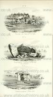
Archaeological Journal Volume 29 1872 Pages 345-350. I much regret that I did not take exact measures and a plan before the fall; as the restoration is not quite a counterpart of tlic original Cromlech, the present dimensions will not supply the deficiency. On Monday, 27th January 1862, I endeavoured to take a photograph of the Cromlech, but in consequence of the deficiency of light was not able to succeed. I was there about three-quarters of an hour, and there was no sign of the adjoining land being disturbed, and on the following Friday, 31st January, the Cromlech [Drewsteighton Cromlech aka Spinsters' Rock, Devon [Map]] fell. On Wednesday, 5th February, I took a photograph of the Cromlech in its fallen condition, and there was no sign of the land being disturbed save where it had been broken by the accident. The following is the minute entered in my journal: "The southerly and easterly stones had given way, and tho quoit had fallen leaning against the northern stone, and the two others were under it; judging by the small depth of stone in the ground it is a wonder that it did not fall before." The accident probably arose from the following causes: the upright stones had only a hold of from 18 to 24 in. in the groimd; as above stated, the quoit rested on the tops of two stone.s, and against the bevilled top of the third; the southerly and easterly stones, as shown in diagrams in The Essays, page 110, and in Lyson's "Devonshire," page ccccviii., leaned sliglitly to the east, and the position of the quoit resting against the bevilled side of the top of the third caused it to act as a wedge; the soil under the Cromlech is of light granite gravel, and this had been saturated by the winter rains, and the field was in the course of being broken up for a wheat crop, so that the adjoining ground furnished very little lateral support; the wedge-like action of the quoit therefore pressed back the northerly stone, and the quoit, assisted by the sloping position of the two other stones, threw them out of position; the southern was partly broken, and the eastern lifted out of the ground; by natural causes, therefore, and not by wilful mischief, I think the fall was caused.
![]() Become a Member via our 'Buy Me a Coffee' page to read complete text.
Become a Member via our 'Buy Me a Coffee' page to read complete text.
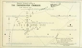
Archaeological Journal Volume 29 1872 Pages 345-350. Notice of the fall and restoration of "the Spinster's Rock [Map]," or cromlech, in the parish of Drewsteignton, in the county of Devon, and of stone circles and avenues formerly existing in its vicinity. By G. Wareing Ormerod, M.A., F.G.S.
