Text this colour links to Pages. Text this colour links to Family Trees. Text this colour are links that `abled for Guests.
Place the mouse over images to see a larger image. Click on paintings to see the painter's Biography Page.
Mouse over links for a preview. Move the mouse off the painting or link to close the popup.
Ffostyll North Long Barrow is in Llanelieu, Breconshire, Prehistoric Wales Neolithic Burials.

Archaeologia Cambrensis Volume LXXVI 1921 Miscellania. The Excavation Of A Megalithic Tomb [Map] In Breconshire by Colwyn Edward Vuilliamy (age 34).
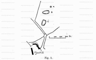
v8KvnzVNThe farmstead of Ffostill is slightly over one and a half miles from the Breconshire border-village of Talgarth, in a north-easterly direction, and about the same distance from the foot of the northern escarpment of the Black Mountains. It is situated at the head of a gully which runs down from the foothills below the Range, and is on relatively high ground—just under the 1,000 ft. contour-line of the Ordnance Survey. Close to the farm buildings there is a most remarkable, if not unique, group of three tumuli. Fig. 1 will explain the placing of the tumuli [Ffostyll North Long Barrow [Map] and Ffostyll South Long Barrow [Map]] far better than a written description, and shows their peculiar arrangement. The axes of the two lower ones point respectively 21 degrees and 67 degrees east of true north. The mound which is marked "A" is a barrow of irregular shape (32 ft. by 29 ft.); while "B" and "C" are magnificent examples of the late Neolithic long barrow, of impressive size and massive construction.
Before proceeding with an account of the excavation of the long barrow "C," which is the main object of this paper, it will not be out of place to give a few particulars regarding the group.
The barrow "A," which bears external resemblance to the burial mounds of the Bronze Age, proved, on a pit being sunk therein, to contain characteristic relics of that period—namely, deposits of thick, unctuous charcoal; very small fragments of calcined bone, reduced in some cases to a white powder; and a few pieces of tiint, one of which was a triangular retouched flake. It had not been disturbed prior to my investigation, but the pit, sunk exactly In its centre, did not reveal any traces either of pottery or of a kist. The blocks of sandstone, of which it is constructed, have been placed with some regard for architectural method.
Colwyn Edward Vuilliamy: On 20th June 1886 he was born to Edwyn Papendiek Vulliamy and Edith Jane Beaven. On 4th September 1971 he died.
![]() Become a Member via our Buy Me a Coffee page to read more.
Become a Member via our Buy Me a Coffee page to read more.
Long Barrows of the Cotswolds. Ffostyll North Long Barrow [Map]
Brecknockshire, 23 S.W. Parish of Llanelieu, 4 *.
Latitude 52° 00' 23". Longitude 3° 1 1' 46". Height above O.D., a little above 1000 feet.
Length 120 feet. Remains of the burial-chamber are visible at the eastern end, consisting of five vertical slabs, two on each side and the fifth closing the eastern end of the chamber. Further west on the mound (which is quite well preserved) are two other large stones, one of them probably once the capstone covering the chamber described. The mound is distinctly egg-shaped; there are no certain signs of a surrounding wall. The east end and the centre have been much dug about.
This mound and the southern mound adjacent are thus described by the Rev. T. Price ("Carnhuanawc ") in his "Hanes Cyimu (History of Wales) 1842, p.32. (In Welsh; kindly translated for me in the extract given below by Mr. W. H. B. Somerset): "The most notable grave-mounds I saw in Wales are in the parish of Llanelieu, Brecknockshire, on the land of a farm called Ffos-y-tyll. The biggest of these mounds [f.e., the northern] is 45 yards long, 20 yards wide and about 2 yards high; and they showed that they were full of cistvaens of some size - one of which was lately broken up for the sake of the stones. There are still enough left to show its size and its workmanship. It was 10 feet long, 5 feet wide and 8 feet deep, formed of great stones one at each end and two on each side and covered with corresponding stones."
The mound is oriented 67 degrees E. of true north, the wider and higher end being to the east.
Visited August 4th, 1921 and August 17th, 1924.
T. Price. Hanes Cymru (Hist, of Wales), 1842, p. 32.
Western Mail, November 29th, 1921 (C. E. Vulliamy).
![]() Become a Member via our Buy Me a Coffee page to read more.
Become a Member via our Buy Me a Coffee page to read more.