Text this colour is a link for Members only. Support us by becoming a Member for only £3 a month by joining our 'Buy Me A Coffee page'; Membership gives you access to all content and removes ads.
Text this colour links to Pages. Text this colour links to Family Trees. Place the mouse over images to see a larger image. Click on paintings to see the painter's Biography Page. Mouse over links for a preview. Move the mouse off the painting or link to close the popup.
Harold's Stones, Trellech is in Trellech, Monmouthshire, Prehistoric Wales Standing Stones.
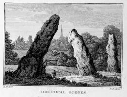
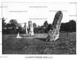
Harold's Stones, Trellech [Map]. Three large monoliths. Trellech means ‘the place of the three stones'. The three stones or monoliths lean at different angles to each other and vary in height from 8 feet, 10 feet and almost 13 feet, the tallest stone having sunk into the ground and slipped leaving it at a crazy angle. A fourth standing stone apparently once stood close by but was robbed-away or destroyed in the late 18th century. The stones are made of conglomerate rock that is known as ‘Pudding Stone'.
The central stone of the three has been dressed to smooth its surface, and bears two large cup marks on its face. T. Driver, RCAHMW, 22 Jan 2008.
According to legend, the stones were hurled by the giant, Jack o'Kent, from either the Skirrid Fawr [Holy Mountain] twelve miles away to the north-west or, from Beacon Hill, one mile to the east, while he was having a fight or playing a game with another giant or, perhaps the devil? King Harold Godwinson fought a battle hereabouts with a Welsh army in the 11th century; Harold was victorious although he lost many of his men. Some suggest he had the stones erected here to commemorate that battle. However, there is no connection whatsoever with King Harold since the stones pre-date him by thousands of years.

Historical Tour in Monmouthshire. From Monmouth I made an excursion to the village of Trelech, remarkable for three druidical stones [Harold's Stones, Trellech [Map]], which stand in a field adjoining the high road, at a small distance from the church, and from which the place is said to derive its appellation. Some persons have erroneously supposed that they once supported a cromlech, which is impossible, because the distance of the middle stone from the smallest is not less than fourteen feet, and from the largest near twenty. The perpendicular height of the smallest is nine feet two inches, of the middle ten feet one inch, and of the largest eleven feet ten inches; they all incline; the largest is fifteen feet long above the ground, and fourteen in circumference at the base.

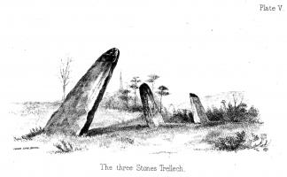
An Account of Some of the Rude Stone Monuments and Ancient Burial Mounds in Monmouthshire. Plate V. The three stones [Harold's Stones, Trellech [Map]] now remaining at Trellech, and from which the town derives its name ( Tre - Town and Lech - Stone ) probably formed part of a large circle which stood at some little distance round a sepulchral mound. The two largest stones decline very considerably from the perpendicular, but whether designedly so placed, or not, it is impossible to say. The idea that treasure was buried at the foot of such great stones, often caused their destruction in the endeavour to reach it; or the ground around them was so much disturbed in the process, that their original perpendicular position was changed in after years. The largest stone measures 14ft, 4in. on the South East side, but a perpendicular line from its apex to the ground on the opposite side gives only 12ft. At the distance of 20ft. to the North stands the second of the stones, which is 10ft. high by 2ft. 6in. wide by 2ft. 4in thick. and at 14ft. 6in. in the same direction is the third, which is 8ft. high, 3ft. 5in wide by 15in. thick; no mark of tool, or carving can be detected on either of them, and they are all conglomerate.
Long Barrows of the Cotswolds. Harold's Stones, Trellech [Map]
Monmouthshire, 20 N.E. Parish of Trelleck. 114.
Latitude 51° 44' 32". Longitude 2° 43' 31". Height above O.D. about 670 feet.
Mr. J. G. Wood, M.A., F.S.A., points out that these three stones cannot possibly be the remains of a circle, as suggested by Mrs. Bagnal-Oakeley, since the diameter would be 672 feet, far greater than that of the Keswick Circle, and quite impossible here on account of the nature of the ground. With reference to the name "Harold's Stones" Mr. Wood remarks:— "A stone such as these was called Har-stan, which means old or hoary. Hence Dr. Grifiin (that first class guesser) probably invented 'Harold's Stones.'"
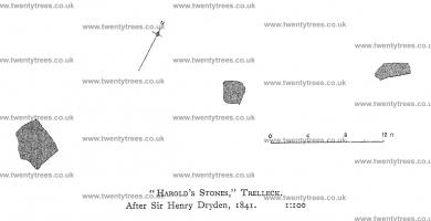
A plan (reproduced here) elevation and sketch of the stones is amongst the Lukis MSS. in the Lukis Museum, Guernsey. From these it appears that they are oriented in a direction 72 degrees E. of true north. The S.W. stone leans considerably and is eleven feet high. The middle stone is 9 ft. 11 ins. high. The N.E. stone is 8 ft. 3 ins. high. The original drawing is by Sir Henry Dryden, and is dated July 6th, 1841, There are also two copies. The purpose of these short alignments of huge uprights is obscure. Comparisons are suggested with the "Five Kings," near Rothbury, Northumberland, and the "Devil's Arrows" near Boroughbridge, Yorks.
Rude Stone Monuments in Monmouthshire, by M. E. Bagnall-Oakeley, 1889, pp. 13-15. Plates V. (view) and VI. (plan),
Lukis Collection (MSS), Lukis Museum, Guernsey.


![]() Become a Member via our 'Buy Me a Coffee' page to read complete text.
Become a Member via our 'Buy Me a Coffee' page to read complete text.