Cursus Barrows
Cursus Barrows is in Station 5 Amesbury North.
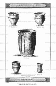
No. 42 [Map]. Nearly opposite the last mentioned barrow, but on the south side of the turnpike road; is a neat circular tumulus, sixty-six feet in diameter, and six feet in elevation, which was opened in 1803, and produced within a circular cist, an interment of burned bones, and a brass pin with part of its handle, deposited in a neat and perfect urn; the latter of which is engraved in Tumuli Plate XVI.

No. 43 [Map] and No. 44 [Map], These two barrows are included within the boundaries of the CURSUS, and very near the western end of it. In opening the first of these, our labourers discovered, at the depth of three feet, the skeleton of an adult, with a drinking cup, and on the floor of the barrow, another of a child. We afterwards, in a shallow cist, found the third skeleton of-a man, lying with his head to the north, and close to it, on the right side, was a curious pebble, and under his left hand was a dagger of brass. The pebble is kidney-formed, of the sardonyx kind, striated transversely with alternate spaces, that give it the appearance of belts; besides these stria, it is spotted all over with very small white specks, and after dipping it into water, it assumes a sea green colour.
In the adjoining barrow, No. 44 [Map], we found only a simple interment of burned bones.
The next barrows that occur in our Iter westward, are three in number, placed nearly in a line parallel to each other. No. 45 [Map], 46 [Map], 47 [Map], all of which proved uninteresting in their contents. The first and last produced simple interments of burned bones; the second, a rude urn with cremation.
No. 50 [Map] is a circular bowl-shaped barrow, in the examination of which, we experienced much perplexity, although not uncommon, owing the Britons having adopted so many modes of burial. At the depth of five feet, we found a regular stratum af flints, intermixed with black vegetable mould; on removing which, we came to the floor of the barrow, in which some excavations had been made, and channels formed. One of these was connected with the cist, which contained a skeleton lying from south to north; in another channel, we found a large branch of a stag's horn; and in a little corner, we took out a shovel-full of bones, intermixed with earth, which were broken almost as small as chaff. Near the feet of the skeleton lay a considerable quantity of very small bones of birds or mice. The day being far advanced, we did not pursue all the channels, and it is very probable that this barrow may contain other skeletons.
No. 51 [Map], a fine bell-shaped barrows ninety-five feet in diameter, and seven feet in elevation. At the depth of four feet and a half in the native soil, viz. eleven feet and a half from the summit, we found two skeletons with their heads laid towards the north; the one, an adult, the other, a young person, not more than about twelve years of age.
No. 52 [Map] and No. 53 [Map]. We were unsuccessful in our attempts on these two large barrows. In the former, we perceived several marks of very intense fire, with some earth, quite black, and some burned to a brick colour. In the latter, near the centre, we found a circular cist containing only ashes, but missed the primary interment. An unusual quantity of small bones, probably of birds, was dispersed about the barrow.
No. 54 [Map]. A fine bell-shaped barrow, eighty feet in diameter, and seven feet in elevation, produced on the floor and near the centre, a circular cist, about eighteen inches wide, and one foot deep, full of wood ashes. and a few fragments of burned bones. About two feet to the north of the above was another cist, of an oblong form, much larger and deeper than the other, which contained an interment af burned bones, piled up ill heap in the centre of the cist.
I shall now direct my steps back towards Amesbury, over a beautiful down, abounding with tumuli of various descriptions, The first, group that occurs, is situated near the northern limits of our map, and is numbered from 57 to 65, and consists of four Druid, and five circular barrows. As they all bore the marks of prior opening, I did not attempt any of them: some had been explored a few years ago, by Mr. CUNNINGTON, at a time when no idea was entertained of prosecuting his researches to the present extent, and when no very regular account was kept of his discoveries.1
Note. No. 57 [Map], No. 58 [Map], No. 59 [Map], No. 60 [Map], No. 61 [Map], No. 62 [Map], No. 63 [Map], NO. 64 [Map], No. 65 [Map].
We now come to three large barrows on the declivity of the hill, 66, 67, 68.