

Intervisibility and Alignment of Avebury Monuments is in Avebury Late Neolithic Early Bronze Age.
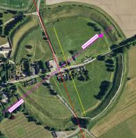
Taking the Centre of the Henge as where the lines between the entrances cross then a line drawn from the Centre to the extant stone [Map] in the north-east quadant is aligned to the Midwinter Sunset and Midsummer Sunrise - the magenta line on the Schematic.
It appears that the Marlborough Mound [Map] is visible from Silbury Hill [Map] - the blue line on the Schematic. If it is it suggests the Marlborough Mound and Silbury Hill were constructed for the same purpose?

The light orange is land above 150m. The dark orange is land above 200m.
