Europe, British Isles, South-West England, Wiltshire, Avebury Henge and Stones, Avebury Stone Circles
Avebury Stone Circles is in Avebury Henge and Stones [Map], South England Stone Circles, Avebury Late Neolithic Early Bronze Age.
Europe, British Isles, South-West England, Wiltshire, Avebury Henge and Stones, Avebury Stone Circles, Avebury Ring Stone [Map]![]()
Avebury by William Stukeley. Exactly in the southern end of the line that connects the two centers of these temples, viz. in that pasture marked IX. in our ground-plot, is an odd stone standing [Map], not of great bulk. It has a hole wrought in it, and probably was designed to fasten the victim, in order for slaying it. This I call the ring-stone [Map]. From this we may infer the like use of that stone at Stonehenge, in the avenue near the entrance into the area of the temple. I spoke of it under the name of crwm leche, p. 33. It has a like hole in it.
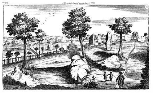
Avebury by William Stukeley. Table XVII. A View of the South Temple July 15 1723. [Possibly the Avebury Ring Stone [Map] middle right.]
Wiltshire Archaeological Magazine 1857 V4 Pages 307-363. In the southern end of the line that connected the two centres of these temples, and between the southern temple and the circumvallation, a single stone was standing in Stukeley's time. It was not of great bulk, but it had a hole wrought in it, to which Stukeley thought that the victim was attached before it was slain. This, which he called the "Ring Stone [Map]," has entirely disappeared.
Archaeologia Volume 84 1935 Section VI. Mention should be made of the position of the ‘Ring-stone [Map]’ which stood in Stukeley’s time. The centre of the depression marking the spot is 60 ft. S. of the southern outer circle, and 14 ft. W. of a line continued through the centre of the N. and S. groups of circles.
Europe, British Isles, South-West England, Wiltshire, Avebury Henge and Stones, Avebury Stone Circles, Avebury Outer Circle
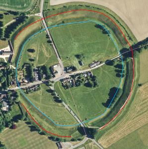
Avebury Outer Circle is a Stone Circle that follows the ditch the stone being around 5m from its edge. The diameter is around 330m. Some stones are missing; it is believed originally there were ninety-eight some of which exceeded forty tons. The stones vary in height from 3.6m to 4.2m with the taller ones being near entrances. It is sub-circular ie not a circle. Neither is it symmetrical. Difficult to give the shape a name since it is so irregular.
Diary of a Dean by Merewether. It may be deemed no unprofitable appropriation of our space and time, to give a brief statement of the number of stones originally composing this magnificent temple, what Dr. Stukeley observed, and what we have found there.
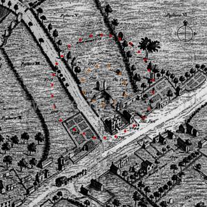
The original outer circle was formed of 100 stones; within this were two smaller circles [Avebury North Circle and Avebury South Circle], not concentric, of (each) 30 stones; within each of these a smaller concentric circle, each of 12 stones; in the centre of the northern inner circle were 3 stones [Map]; in the centre of the southern inner circle 1 stone [Map].
Besides these, each avenue was composed of 200 stones, terminating towards the east on Hacpen Hill, in a double oval, the outer containing 40 stones, the inner 18 stones; in the western range were 2 extra stones about half way, forming as it were a recess; and 1 at the termination.
Archaeologia Volume 84 1935 Section VI. Bare allusion has already been made to the Great Outer Circle which follows the fosse on its inner side. We have put the approximate diameter at 1,108 ft., but it is considerably out of the true, and few of the stones actually touch the circumference of the circle described on the plan. The most accurately placed stones were in the NW. and SE. quadrants. There is much flattening (inwards) on the SW., a short flattening on the N., and a decided outward bulge on the N E.
With regard to the stones it is estimated that just over one hundred of these gigantic sarsens formerly occupied this ring, of which only nineteen are seen to-day ten standing and nine recumbent (some partly overgrown). The average distance apart was apparently in the region of 38 or 40 ft.
Ihe most southern part of the outer circle of the southern group is 134 ft. from the line of the Great Outer Circle to the S., whereas the most northern part of the outer circle of the northern group is 249 ft. from the nearest part of the Great Outer Circle to the north.
Europe, British Isles, South-West England, Wiltshire, Avebury Henge and Stones, Avebury Stone Circles, Avebury Outer Circle Stone Markers ![]()
Where stones are missing Alexander Keiller commissioned stone markers to idicate their position.
Europe, British Isles, South-West England, Wiltshire, Avebury Henge and Stones, Avebury Stone Circles, Avebury North Circle
Avebury North Circle is 98m diameter Stone Circle. Only two of its stones are extant.
The North Circle may have been two circles, one within another, concentric, with the cove [Map] at its centre as shown on the Frontspiece to Stukeley's Chapter 5 where he has also shown the years in which the stones were destroyed ranging from 1694 to 1718. Stukeley's drawing shows and outer circle of twenty-eight stones and an inner circle of eleven stones.
Avebury by William Stukeley. Table XIII. A View of the Remains of the Northern Temple at Abury. Aug. 1722. A. Abury Steeple. B. the cove [Map]. C. Windmill hill.
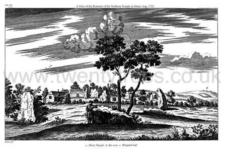
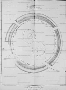
Avebury by William Stukeley. Of the two great temples [Avebury South Circle and Avebury North Circle] included in the area of the great circle of stones. Each consists of two concentrick circles. One has a central obelisc or ambre, a very high stone in the center. The Egyptians called an obelisc an ambre. The other temple has a cove [Map] in the center, composed of three stones of a stupendous bulk, set in a nich-like figure. A short history of the destroyers of this noble work, but a very few years ago.
Avebury by William Stukeley. Of the exterior circle of this northern temple but three stones are now left standing, six more lying on the ground, one whereof in the street by the inn-gate. People yet alive remember several standing in the middle of the street; they were burnt for building, anno 1711. That at the corner of the lane, going to the north gate of the town, not many years since lying on the ground, was used as a stall to lay fish on, when they had a kind of market here. The ruin of the rest is noted in the ground-plot, and so of the others. But they told us, that about a dozen years ago both circles were standing, and almost entire. Those in the closes behind the inn, were taken up a year ago; (this was when I first went thither, about 1718,) farmer Green chiefly demolished them to build his house and walls at Bekamton. Of the southern temple several stones were destroyed by farmer John Fowler, twelve years ago; he owned to us that he burnt five of them; but fourteen are still left, whereof about half standing. Some lie along in the pastures, two let into the ground under a barn, others under the houses. One lies above ground under the corner of a house, over-against the inn. One buried under the earth in a little garden. The cavities left by some more are visible, in the places whereof ash-trees are set. All those in the pastures were standing within memory.
Colt Hoare 1812. Plate Xl. By this plan I have been anxious to convey to my readers, correct idea of the grand circle at Abury in its original state, as most ingeniously developed by Dr. Stukeley. The site of the temples is taken from nature. The fine British earth-work called Oldbury Castle, appears at a distance in the centre of the view. The object of this Plate is to indicate the respective site of each temple; and the number of stones with which each composed; thirty in the out-ward, and twelve in the inner circles. The one situated towards the north, or right hand side, had three large upright stones in the centre of its area, designating the COVE [Map], where the altar was placed. The centre of the Southern Temple was marked by an upright stone named the OBELISK [Map], in a line with which, and between the temple and the outward circumvallation, was another single stone, with a perforation in it and denominated by Stukeley, the RING STONE [Map]. To this he supposes the victim was fastened previous to its sacrifice. The stones that accompanied the outward circumvallation, amounted to one hundred. The breaks in the vallum A. [Map] B. [Map] point out the spots where the two avenues issued from the central Temple; the one on the left side leading to Kennet; the other towards the centre to Beckhampton.
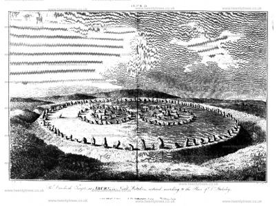
Diary of a Dean by Merewether. It may be deemed no unprofitable appropriation of our space and time, to give a brief statement of the number of stones originally composing this magnificent temple, what Dr. Stukeley observed, and what we have found there.
The original outer circle was formed of 100 stones; within this were two smaller circles [Avebury North Circle and Avebury South Circle], not concentric, of (each) 30 stones; within each of these a smaller concentric circle, each of 12 stones; in the centre of the northern inner circle were 3 stones [Map]; in the centre of the southern inner circle 1 stone [Map].
Besides these, each avenue was composed of 200 stones, terminating towards the east on Hacpen Hill, in a double oval, the outer containing 40 stones, the inner 18 stones; in the western range were 2 extra stones about half way, forming as it were a recess; and 1 at the termination.
Wiltshire Archaeological Magazine 1857 V4 Pages 307-363. Of the northern circle three stones (one of them much reduced in size) are now erect and one prostrate. One which was standing when Sir Richard Hoare described Abury has since been broken up. It projected into the road leading to Winterbourne Monkton, as may be seen in Stukeley's large plan; and as the carters were constantly driving against it, it was removed when the road was widened, and its fragments now form the wall which serves for the eastern boundary of the road.
Wiltshire Archaeological Magazine 1866 V10 Pages 209-216. Excavations at the Northern Circle.
We began our operations at the north of the area in the meadow just beyond the "Cove" of the northern circle, and dug a trench on either side of the great stone marked "e" in Mr. Long's map, (see Wiltshire Magazine, vol. iv., p. 18) but there were not any traces of any burial deposit whatever. In the mould just under the turf were two or three fragments of British pottery, bones of sheep, and a small piece of burnt micaceous sandstone — not sarsen.
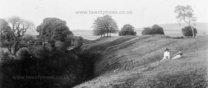
Keiller Collection Photos. May 1911. Two figures, thought to be Harold Gray's (age 39) wife Florence (age 35) and their son Lionel (age 10), with two stones of Avebury’s Northern Inner Circle.
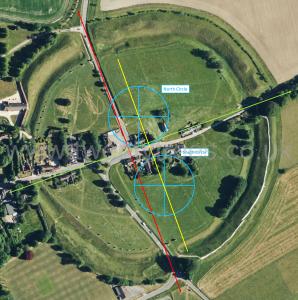
The North [Map] and South [Map] entrances appears to align the two inner circles, the North and South circles. A line drawn between their centres is parallel with the line between the North [Map] and South [Map] entrances - the yellow line on the Schematic.
Europe, British Isles, South-West England, Wiltshire, Avebury Henge and Stones, Avebury Stone Circles, Avebury North Circle Extant Stones ![]()
Only two stones remain. It isn't clear how many there originally were.
Europe, British Isles, South-West England, Wiltshire, Avebury Henge and Stones, Avebury Stone Circles, Avebury South Circle
Avebury South Circle is a 108m diamerer Stone Circle. Little of it remains. It is believed a single monolith [Map] 5.5m tall stood at its centre.
Avebury by William Stukeley. The centers of these two double circles are 300 cubits asunder. Their circumferences or outward circles are 50 cubits asunder, in the nearest part. By which means they least embarrass each other, and leave the freest space about 'em, within the great circular portico (as we may call it) inclosing the whole; which we described in the former chapter. There is no other difference between these two temples (properly) which I could discover, save that one, the southermost, has a central obelisc, which was the kibla, whereto they turned their faces, in the religious offices there performed: the other has that immense work in the center, which the old Britons call a cove [Map]: consisting of three stones placed with an obtuse angle toward each other, and as it were, upon an ark of a circle, like the great half-round at the east end of some old cathedrals: or like the upper end of the cell at Stonehenge [Map]; being of the same use and intent, the adytum of this temple. This I have often times admired and been astonished at its extravagant magnitude and majesty. It stands in the yard belonging to the inn. King Charles II. in his progress this way, rode into the yard, on purpose to view it.
Avebury by William Stukeley. Of the exterior circle of this northern temple but three stones are now left standing, six more lying on the ground, one whereof in the street by the inn-gate. People yet alive remember several standing in the middle of the street; they were burnt for building, anno 1711. That at the corner of the lane, going to the north gate of the town, not many years since lying on the ground, was used as a stall to lay fish on, when they had a kind of market here. The ruin of the rest is noted in the ground-plot, and so of the others. But they told us, that about a dozen years ago both circles were standing, and almost entire. Those in the closes behind the inn, were taken up a year ago; (this was when I first went thither, about 1718,) farmer Green chiefly demolished them to build his house and walls at Bekamton. Of the southern temple several stones were destroyed by farmer John Fowler, twelve years ago; he owned to us that he burnt five of them; but fourteen are still left, whereof about half standing. Some lie along in the pastures, two let into the ground under a barn, others under the houses. One lies above ground under the corner of a house, over-against the inn. One buried under the earth in a little garden. The cavities left by some more are visible, in the places whereof ash-trees are set. All those in the pastures were standing within memory.
Avebury by William Stukeley. Table XVII. A View of the South Temple July 15 1723. [Possibly the Avebury Ring Stone [Map] middle right.]

Avebury by William Stukeley. Of the two great temples [Avebury South Circle and Avebury North Circle] included in the area of the great circle of stones. Each consists of two concentrick circles. One has a central obelisc or ambre, a very high stone in the center. The Egyptians called an obelisc an ambre. The other temple has a cove [Map] in the center, composed of three stones of a stupendous bulk, set in a nich-like figure. A short history of the destroyers of this noble work, but a very few years ago.
Wiltshire Archaeological Magazine 1857 V4 Pages 307-363. Of the southern of these circles two stones remain erect and three prostrate. Three recumbent stones marked in early impressions of Sir R. Hoare's survey of 1812, were removed between that year and 1819. Mr. Lawrence, the venerable Clerk of Abury, pointed out to me their sites in a garden adjoining his own.
Wiltshire Archaeological Magazine 1866 V10 Pages 209-216. Excavations at the Southern Circle.
We now crossed over to the south circle, and found the exact centre, by careful measurement from the still standing stones of the outer circle: since (together with perfectly distinct traces of cavities where others stood) enough of these stones remained to enable us to obtain an accurate segment of the circle. Here then, at a distance of 163 feet from the outside stones of the circle, we sunk a large square hole; and our measurements had not deceived us: for in the exact centre, we found large quantities of burnt sarsens, including chips, flakes, and much charred matter, proof positive that this was the site of the -large central stone, and the scene of its destruction. And now starting from this centre we cut a long trench very nearly due west, in a straight line towards the westernmost of the great stones still standing in the outer circle. This was a work of considerable time, for the trench was extended to a distance of sixty feet from the centre, as we thought thus to ascertain the possible existence of any inner circle, but nothing was found. Subsequently we cut other short trenches from the centre: one towards the north, another towards the south, and a third towards the east; in all of which large quantities of burnt sarsens, flakes, chips, and burnt matter were exhumed, and all doubtless belonging to the ponderous mass which once occupied the centre of this southern sanctuary.
The North [Map] and South [Map] entrances appears to align the two inner circles, the North and South circles. A line drawn between their centres is parallel with the line between the North [Map] and South [Map] entrances - the yellow line on the Schematic.

Europe, British Isles, South-West England, Wiltshire, Avebury Henge and Stones, Avebury Stone Circles, Avebury South Circle Extant Stones ![]()
. There are five extant Avebury South Stone Circle stones.
Europe, British Isles, South-West England, Wiltshire, Avebury Henge and Stones, Avebury Stone Circles, Avebury South Circle Obelisk [Map]![]()
Avebury by William Stukeley. Table XVI. Part of the South Temple from the Central Obelisk [Map] 10 July 1723.
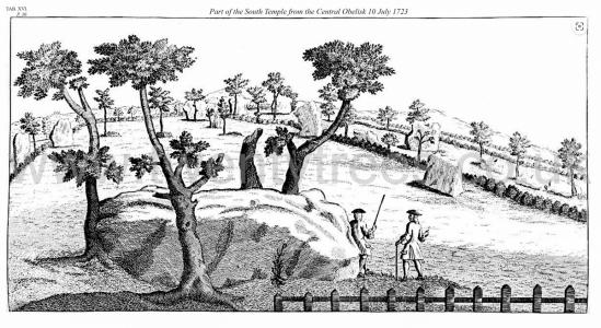
Avebury by William Stukeley. The central obelisk [Map] of this temple is of a circular form at base, of a vast bulk, 21 feet long, and 8 feet 9 inches diameter; when standing, higher than the rest. This is what the scripture calls a pillar, or standing image, Levit. xxvi. 1. These works, erected in the land of Canaan by the same people, the Phœnicians, as erected ours, were ordered to be demolished by the Israelites, because at that time perverted to idolatry. All the stones, our whole temple, were called ambres, even by our phœnician founders; but this particularly. The Egyptians by that name called their obeliscs; which Kircher did not rightly understand, interpreting it to be sacred books; but meaning petræ ambrosiæ, main ambres in celtic, anointed, consecrated stone; Manah, the name of a great stone of this sort which the Arabians worshipped. They were called likewise, gabal, and the present word kibla or kebla comes from it, but in a larger sense. Elagabalus is hence derived after they turned these kiblas into real deities. It means the god obe25lisc; and hence our english words, gable end of a house, javelin or roman pile, and gaveloc a sharp iron bar.
Diary of a Dean by Merewether. It may be deemed no unprofitable appropriation of our space and time, to give a brief statement of the number of stones originally composing this magnificent temple, what Dr. Stukeley observed, and what we have found there.
The original outer circle was formed of 100 stones; within this were two smaller circles [Avebury North Circle and Avebury South Circle], not concentric, of (each) 30 stones; within each of these a smaller concentric circle, each of 12 stones; in the centre of the northern inner circle were 3 stones [Map]; in the centre of the southern inner circle 1 stone [Map].
Besides these, each avenue was composed of 200 stones, terminating towards the east on Hacpen Hill, in a double oval, the outer containing 40 stones, the inner 18 stones; in the western range were 2 extra stones about half way, forming as it were a recess; and 1 at the termination.
Wiltshire Archaeological Magazine 1857 V4 Pages 307-363. In the centre of the southern inner circle of twelve stones was one stone [Avebury South Circle Obelisk [Map]], described by Stukeley as having been of a circular form at the base, of a vast bulk, 21 feet long, 8 feet 9 inches in diameter, and when standing, higher than the rest. It formed, in Stukeley's opinion, the "Kibla," "Ambre," or central obelisk of this temple. Nothing now remains of it.
Archaeologia Volume 84 1935 Section VI. The true centre of these mathematically accurate circles is marked by a decided depression from which the so-called ‘Obelisk [Map]’ was removed.1
Note 1. The Rev. A. C. Smith (North Wilts., p. 142) mentions an urn full of bones ‘found towards the centre of the southern temple in 1880’ by Mr. Pratt when he was sinking a hole for a flagstaff, on the occasion of a village fete in that field. The urn was broken to pieces, and the fragments carried off by the children.
This burial by cremation was probably deposited here considerably after the construction of the circles.
A traditional ‘sanctity’ still lingers round this spot.
Europe, British Isles, South-West England, Wiltshire, Avebury Henge and Stones, Avebury Stone Circles, Avebury South Circle Z Feature [Map]![]()
The Avebury South Circle Z Feature [Map] is somewhat vague. Today it is marked by a line of concrete stone markers. It may have been have square of stones enclosing the Avebury South Circle Z Feature [Map] - see Universities of Leicester and Southampton discovery?
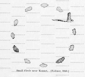
Europe, British Isles, South-West England, Wiltshire, West Kennet, Falkner's Circle [Map]![]()
Falkner's Circle is also in Avebury Henge and Stones [Map].
Falkner's Circle [Map] is a 37m diameter Stone Circle of twelve stones, of which only one 1.3m high stone remains, in the Prehistoric Avebury Landscape around 470m south of the Avebury Henge South Entrance [Map] adjacent to the West Kennet Avenue.
Wiltshire Archaeological Magazine 1857 V4 Pages 307-363. 1840. In the dip of the hill between the Kennet avenue anda slight oblong earthwork on the slope of Hakpen Hill,1 a solitary stone is standing. Mr. Falkner of Devizes, has fayored me with the following account of his observations in connection with it. "The stone which you saw in a field on the left, when you went along the avenue towards Kennet, was seen by me in 1840. I went to it, and found it was one of a circle [Falkner's Circle [Map]] that had existed at some former period. There were two other stones lying on the ground, and nine hollow places, from which stones had been removed, making twelve altogether. I made a note of it at the time, and the person with whom I was riding observed it also. The circle was then in a meadow, which was broken up a few years afterwards, and two of the stones removed. The circle was 2824 yards from the nearest part of the avenue. I could not have been mistaken as to the fact of a circle being there, and considered the discovery of sufficient importance to write to the Rev. E. Duke on the subject, who was not aware of what I told him, nor could he explain the matter at all,—only suggesting that the stones might have been set round a large tumulus,—but the ground was quite flat within the circle, which was about 120 feet in diameter."
Note 1. I use the words "Hakpen Hill" because this hill is so designated in the plan, but the Hakpen Hill, properly so called, does not extend so far to the south, or beyond the road leading from Abury to Rockley. See Ordnance Map.
