Europe, British Isles, South-West England, Wiltshire, Avebury Henge and Stones [Map]
Avebury Henge and Stones is in Avebury, Wiltshire [Map].
Avebury Henge and Stones [Map] describes the monuments associated with the Late Neolithic Early Bronze Age Period, aka around 2400BC. Those monuments are:
Avebury Stone Circles, including:
Avebury North Circle, with the Avebury North Circle Cove [Map] at its centre,
Avebury South Circle, with the Avebury South Circle Obelisk [Map] at its centre,
West Kennet Avenue, with the The Sanctuary [Map] at its end,
Beckhampton Avenue, with the Long Stones Cove aka Devil's Quoits [Map] at its end,
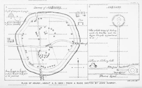
Wiltshire Archaeological Magazine 1857 V4 Pages 307-363. Aubury [Map] is four miles west from Marleborough in Wiltshire, and is peradventure the most eminent and entire monument of this kind in the Isle of Great Britaigne. (I take this old ill-shapened monument to be the greatest, most considerable, and the least ruinated of any of this kind in our British Isle.) It is very strange that so eminent an Antiquitie should lye so long unregarded by our Chorographers: Mr......... only names it.
"It is environed with an extraordinary great vallum [or Rampart] as great, and as high as that at Winchester, [which is the greatest Bulwark that I have seen]: within which is a Graffe [ditch] of a depth and breadth proportionable to it: wherefore it could not be designed for a Fortification, for then the Graffe would have been on the outside of the Rampart.
"From the entrance at a to that at β is sixty perches.
"From the entrance at γ to that at δ the same distance: and the breadth of the rampart is fower perches; and the breadth of the Graff the same distance. (See plate 2, section 1.)
"Round about the Graffe, (sc. on the edge or border of it) are pitched on end huge stones, as big, or rather bigger than those at Stoneheng: but rude and unhewen as they are drawn out of the earth:—whereas those at Stoneheng are roughly-hewen. Most of the stones thus pitched on end, are taken away: only here and there doe still remain some curvilineous segments: but by these one may boldly conclude, that heretofore they stood quite round about, like a Crowne;
'sed longa vetustas
Destruit, et saxo longa senecta nocet.'1
Note 1. but a long age, It destroys, and harms the long old stone.'

Wiltshire Archaeological Magazine 1857 V4 Pages 307-363. Abury [Map] By William Long, Esq., M.A.
Wiltshire Archaeological Magazine 1866 V10 Pages 209-216. Excavations at Avebury [Map]. Under the Direction of the Secretaries of the Wiltshire Archaeological and Natural History Society, September 29th,— October 5th, 1865.
Note. [In preparing the following account, I have had the advantage of comparing the notes which Mr. King and Mr. Cunnington also took of our daily work as it proceeded, and from the three several accounts I have compiled this paper. Alfred Charles Smith]
Wiltshire Archaeological Magazine 1878 V17 Pages 327-335. Abury Notes [Map]. By William Long, Esq., M.A., F.S.A.
Wessex from the Air Plate 36. Avebury [Map]

Archaeologia Volume 84 1935 Section VI. The Avebury Excavations [Map], 1908-1922. By H. St. George Gray (age 62), Esq., F.S.A. Read 15th November 1934.
Keiller's Slides TR000011. 1938. General view of the south west sector of the henge at Avebury [Map], prior to restoration.
Keiller's Slides TR000020. 1938. General view of men working on an excavation around an unidentified stone in the henge at Avebury [Map]
Antiquity 1939 Volume 13 Pages 223-233. Avebury [Map]. Summary of Excavations, 1937 and 1938 by Alexander Keiller (age 49).
Note 1. See Plate I, facing p. 232. My thanks are expressed to Major Allen for permitting the use of this air-photograph.
In 1943 Alexander Keiller (age 53) sold his holdings in Avebury [Map] to the National Trust for £12,000.
Europe, British Isles, South-West England, Wiltshire, West Kennet, Falkner's Circle [Map]![]()
Falkner's Circle is also in Avebury Stone Circles, .
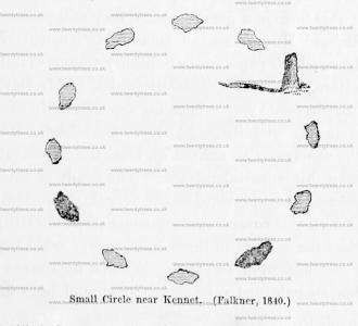
Falkner's Circle [Map] is a 37m diameter Stone Circle of twelve stones, of which only one 1.3m high stone remains, in the Prehistoric Avebury Landscape around 470m south of the Avebury Henge South Entrance [Map] adjacent to the West Kennet Avenue.
Wiltshire Archaeological Magazine 1857 V4 Pages 307-363. 1840. In the dip of the hill between the Kennet avenue anda slight oblong earthwork on the slope of Hakpen Hill,1 a solitary stone is standing. Mr. Falkner of Devizes, has fayored me with the following account of his observations in connection with it. "The stone which you saw in a field on the left, when you went along the avenue towards Kennet, was seen by me in 1840. I went to it, and found it was one of a circle [Falkner's Circle [Map]] that had existed at some former period. There were two other stones lying on the ground, and nine hollow places, from which stones had been removed, making twelve altogether. I made a note of it at the time, and the person with whom I was riding observed it also. The circle was then in a meadow, which was broken up a few years afterwards, and two of the stones removed. The circle was 2824 yards from the nearest part of the avenue. I could not have been mistaken as to the fact of a circle being there, and considered the discovery of sufficient importance to write to the Rev. E. Duke on the subject, who was not aware of what I told him, nor could he explain the matter at all,—only suggesting that the stones might have been set round a large tumulus,—but the ground was quite flat within the circle, which was about 120 feet in diameter."
Note 1. I use the words "Hakpen Hill" because this hill is so designated in the plan, but the Hakpen Hill, properly so called, does not extend so far to the south, or beyond the road leading from Abury to Rockley. See Ordnance Map.
