Europe, British Isles, South-West England, Wiltshire, West Kennet, Overton Hill, The Sanctuary [Map]
The Sanctuary is in Overton Hill [Map], Avebury Late Neolithic Early Bronze Age, Avebury Henge and Stones [Map].
The The Sanctuary [Map] is visble from Long Stones Long Barrow [Map] as described by William Stukeley. It was using this information that Benjamin Howard Cunnington and Maud Cunnington née Pegge discovered the location of the The Sanctuary [Map] - the green line on the Schematic.
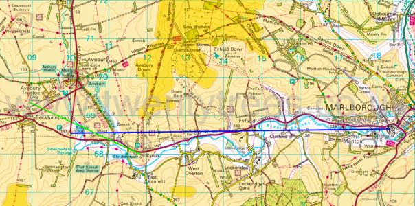 The light orange is land above 150m. The dark orange is land above 200m.
The Ridgeway Path is an ancient footpath that extends from Knap Hill [Map], on the south of the Avebury Plateau, or The Sanctuary [Map], to Ivinghoe Beacon, Buckinghamshire [Map] - a distance of more than eighty miles following the scarp slopes. From Knap Hill [Map] the Ridgeway Path passes The Sanctuary [Map], Avebury Ridgeway Path [Map] where a path leads to the Avebury Henge East Entrance [Map], Barbury Castle [Map], Liddington Castle [Map], Wayland's Smithy Long Barrow [Map], Uffington Castle and White Horse [Map], Segsbury Camp [Map], Scutchamer Knob, Oxfordshire [Map], Goring, Oxfordshire [Map], Swyncome, Oxfordshire [Map], Chinnor, Oxfordshire [Map], Princes Risborough, Buckinghamshire [Map], Boddington Hill Fort, Buckinghamshire [Map], Tring, Hertfordshire [Map], Ivinghoe Beacon, Buckinghamshire [Map].
3000BC. The Sanctuary [Map] is fifty-eight stone-sockets and sixty-two post-holes forming concentric circles located at the southern end of the West Kennet Avenue on Overton Hill next to the Ridgeway Path. The overall diameter is 40m. William Stukeley reported in 1724 that locals called it The Sanctuary. From The Sanctuary may be seen West Kennet Long Barrow [Map], East Kennet Long Barrow [Map] and Windmill Hill Causewayed Enclosure [Map].
The The Sanctuary [Map] is notable for being where the River Kennet and the Ridgeway Path cross.
Around 3000BC a ring of eight wooden posts 4.5m across with a central post was constructed at The Sanctuary [Map]; possibly a round building.
Before 2800BC the first ring was englarged to 6m and a second ring of eight posts of diameter 11.2m was added to The Sanctuary [Map].
After 2800BC a 21m diameter circle of 33 posts was added, and at the same time an inner stone circle of 15 or 16 sarsen stones was added to The Sanctuary [Map] alongside the now middle ring.
Around 2400BC 42 sarsen stones forming a boundary ring 40m across replaced all the timber structures. Possibly around the same time West Kennet Avenue was constructed.
Pepy's Diary. 15 Jun 1668. So took coach again, seeing one place with great high stones pitched round, which, I believe, was once some particular building, in some measure like that of Stonage. But, about a mile off, it was prodigious to see how full the Downes are of great stones; and all along the vallies, stones of considerable bigness [probably The Sanctuary [Map] - see Maud Cunnington], most of them growing certainly out of the ground so thick as to cover the ground, which makes me think the less of the wonder of Stonage, for hence they might undoubtedly supply themselves with stones, as well as those at Abebury. In my way did give to the poor and menders of the highway 3s. Before night, come to Marlborough [Map], and lay at the Hart; a good house, and a pretty fair town for a street or two; and what is most singular is, their houses on one side having their pent-houses supported with pillars, which makes it a good walk. My wife pleased with all, this evening reading of "Mustapha" to me till supper, and then to supper, and had musique whose innocence pleased me, and I did give them 3s.
Wiltshire Archaeological Magazine 1857 V4 Pages 307-363. [Around 1685.] "On the brow of the hill above Kynet, on the right hand of the high way which goes from Bristow to Marleborough, is such a monument [The Sanctuary [Map]] as in pl. (2, sec. 2. and pl. 3, f.1.) called.... The stones are fower and five feet high,.... in number; most of them (now) are fallen downe. I doe well remember there is a circular trench about this monument or temple.1 Here remaines a kind of solemne walk from Kynet to the top of the hill where this monument is. It is at least a quarter of a mile in length,.... foot broad, and the stones distant one from another about.... foot. West Kynet stands in the angle where the walke from Aubury hither, and that from the top of the hill did joine. It lies by the side of a little rivulet called Kynet, which runnes to Marleborough, from whence Cynetium hath its denomination: and 'tis likely that here might in the old time have been the celle or Convent for the priests belonging to these temples.
Note 1. "Mr, Aubury erred in saying there was a circular ditch on Overton Hill." Stukeley's Abury, p. 32.
Colt Hoare 1812. This Overton hill, from time immemorial, the country people, have a high notion of. It was (alas! it was ) a very few years ago, crowned with a most beautiful temple of the Druids. They still call it the Sanctuary [Map]. I doubt not but it was an asylum in Druid times, and the veneration for it has been handed down through all succession of times and people. It had suffered a good deal when I took the prospect of it with great fidefity, anno 1723. Then farmer Green took most or the stones away to his building at Bekhampton, and in the year 1724 farmer Griffin ploughed half of it up; but the vacancy of every stone was most obvious, the hollows still left fresh. In the winter of the same year, the rest were carried off, and the ground ploughed over.
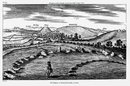
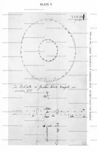
Avebury by William Stukeley. Table XXI. The Hakpen [Map], or head of the Snake, in ruins.
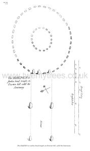
Avebury by William Stukeley. Table XX. The HAKPEN or snakes head temple on Overton hill, calld the Sanctuary [Map].
Avebury by William Stukeley. This Overton-hill, from time immemorial, the country-people have a high notion of. It was (alas, it was!) a very few years ago, crowned with a most beautiful temple of the Druids. They still call it the sanctuary [Map]. I doubt not but it was an asylum in Druid times; and the veneration for it has been handed down thro' all succession of times and people, as the name, and as several other particulars, that will occasionally be mentioned. It had suffered a good deal when I took that prospect of it, with great fidelity, anno 1723, which I give the reader in plate XXI. Then, about sixteen years ago, farmer Green aforementioned took most of the stones away to his buildings at Bekamton; and in the year 1724 farmer Griffin ploughed half of it up. But the vacancy of every stone was most obvious, the hollows still left fresh; and that part of the two circles which I have drawn in the plate, was exactly as I have represented it. In the winter of that year the rest were all carryed off, and the ground ploughed over.
Avebury by William Stukeley. A little way hence is a bit of heath-ground, but the plough will soon have devoured it. Here remains a great barrow, called Longstone long barrow [Map] ; and from hence we see innumerable more barrows. The avenue continued its journey by the corn fields. Three stones lie still by the field-road coming from South-street to the Caln-road. Mr. Alexander told me he remembered several stones standing by the parting of the roads under Bekamton, demolished by Richard Fowler. Then it descends by the road to Cherill, 'till it comes to the Bath-road, close by the Roman-road, and there in the low valley it terminates, near a fine group of barrows, under Cherill-hill, in the way to Oldbury-camp; this is west of Bekamton-village. This point facing that group of barrows and looking up the hill is a most solemn and awful place; a descent all the way from Longstone cove, and directed to a descent, a great way further, down the Bath-road, where no less than five valleys meet. And in this very point only you can see the temple [Map] on Overton-hill, on the south side of Silbury-hill [Map].
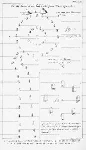
Antiquity 1935 Volume 9 Issue 33 Pages 22-32. 1724. Stukeley's (age 36) original field-sketch of the plan of the Overton Hill stone circles [Map]. Bodleian Library, M.S Gough Maps 231, f. 9v.
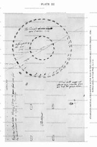
Antiquity 1935 Volume 9 Issue 33 Pages 22-32. 1724. Stukeley's (age 36) original field-sketch of the plan of the Overton Hill stone circles [Map]. Bodleian Library, M.S Gough Maps 231. f. 54r.
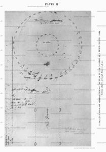
Antiquity 1935 Volume 9 Issue 33 Pages 22-32. 1740. William Stukeley (age 52). For the published plate of the Overton Hill Stone Circles [Map], though not the final version, showing the corcles altered to oval. MS in the possession of Alexander Keiller. See Avebury Chapter VIII.
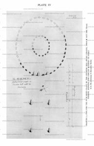
Antiquity 1935 Volume 9 Issue 33 Pages 22-32. 1743. William Stukeley (age 55). Overton Hill Stone Circles [Map]: Plan published in Stukeley's 'Avebury'. Tab XX..
Colt Hoare 1812. On examining this ground plan, we perceive a degree of symmetry, of which, except upon paper, we could form no conception, nor for which could we give credit to the early Britons. We behold the grand circle placed in the centre of the picture, and the huge mount of Silbury in a line opposite to it1. Two avenues, like wings, expand themselves to the right and left, as if to protect the hallowed sanctuary, and the holy mount. The eastern avenue, terminates with a circular temple [Map], thus distinguishing it as a place of peculiar eminence. From the winding form of this work, Dr. Stukeley has very ingeniously developed the form of a serpent, and distinguished this temple as one of that class called by the ancients Dracontia.
This plan receives additional interest by comprehending same groups of barrows, which I investigated, the principal source of the river Kennet, a small portion of the British Track-way, passing from the district of South Wiltshire, throughout the whole extent of Berkshire2, and a large portion of the Roman road between Bath and Marlborough.
Note 1. Dr. Stukeley remarks that the meridian line passed through the centre of the Grand Circle, and of Silbury Hill; and on making our observations, and allowing for the variation of the compass, we find it still does the same.
Note 2. The course of this ridge-way has already been described, page 45. still does the same.
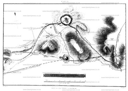
Colt Hoare 1812. 1812. A little way hence is a bit of heath ground, but the plough will soon have devoured it. Here remains a great barrow called Longstone Long Barrow [Map], and from hence we see innumerable more barrows. The avenue continued its journey by the corn fields. Three stones still lie by the field road coming from South-street to the Caln road. Mr. Alexander told me he remembered several stones standing by the parting of the roads under Beckhampton, demolished by Richard Fowler. Then it descends by the road to Cherill, till it comes to the Bath road, close by the Roman road; and there in a low valley it terminates, near a fine group of barrows, under Cherill hill, in the way to Oldhury Camp. This point, facing that group of barrows, and looking up the hill, is a most solemn and awful place. A descent all the way from Longstone Cove, and directed to a descent a great way further down the Bath road, where no less than five valleys meet, and in this very point only you can see the Temple [Map] on Overton hill, on the south side of Silbury hill [Map].
Note 1. By the above description: we have been guided in our plan as to the termination of the Bcekhampton avenue, which our author observes, ended in a valley, near a fine group of barrows, H.
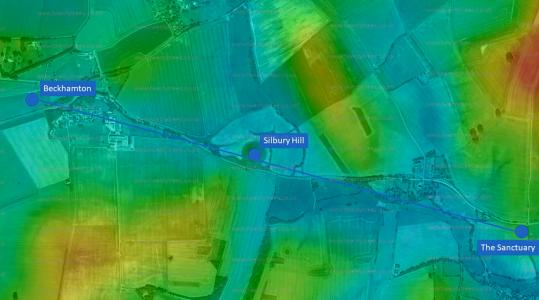 Sourced from topographic-map.com
Wiltshire Archaeological Magazine 1857 V4 Pages 307-363. The Avenues and Sanctuary
We now proceed to the avenues, each of which was composed of 200 stones, and was of a sinuous course, and about a mile and a half in length. The head of the serpent, (which reptile the whole work was supposed by Stukeley to have been designed to represent,) rested on Overton or Kennet Hill, and the tail extended from Abury in the direction of Beckhampton. The head was called the "Sanctuary [Map]," and was composed of two concentric ovals, the outer containing 40, the inner 18 stones.1 The diameter of the outer oval, according to Stukeley, was 138 feet 4 inches by 155 feet 6 inches. That of the inner one was 44 feet 11 inches by 51 feet 103 inches. Of these circles, as he found them in 1723, Stukeley gives an engraving.2 They stood in what is still called Mill Field, and their sites are shown in Nos. 20, 21, and 29 of Stukeley's illustrations. Farmer Green took away the stones and Farmer Griffin ploughed up the ground, in 1724. 'The loss of this work," says Stukeley [See Stukeley],3 "I did not lament alone; but all the neighbours (except the person that gain'd the little dirty profit) were heartily griev'd for it. It had a beauty that touch'd them far beyond those much greater circles in Abury town. The stones here were not large, set pretty close together, the proportions of them with the intervals, and the proportions between the two circles, all being taken at one view under the eye, charmed them. The great stones of the great circles at Abury were not by them discern'd to stand in circles, nor could they easily be persuaded of it. But these of the sanctuary they still talk of with pleasure and regret."
Note 1. "It can hardly now be thought that the number was really 19, as some have supposed, e.g. the Rev. E. Duke, 'Druidical Temples of Wiltshire,' p. 64, 178. Several megalithic circles in Cornwall are of 19 stones, also the inner oval at Stonehenge, as is thought; and each side of the avenue at Classerness; in all of which the number 19 is with some reason believed to refer to the Metonie Cycle." —[Dr. Thurnam. ]
Note 2. For Aubrey's account of these circles on Overton Hill, see above p. 317, and for his plan of them, see plate 3, fig. 1. He makes the diameter of the outer circle 45 paces, of the inner 16; the outer circle to consist of 22 stones, the inner of 15, There are no traces on his plan of the cireular trench around it, which he mentions in his description. The mode in which the avenue narrowed and bent at its junction with the outer circle, as shown by him, is very curious, and favours the notion of a dracontine form.
Note 3. It is difficult to discover the extent of Stukeley's acquaintance with the 'Monumenta Britannica.' With reference to the 'Sanctuary,' he writes as if he had not seen more than the short account published in Gibson's edition of Camden's 'Britannia;' while it is clear from pages 33 and 45 of his "Abury," that he must have known more of the MS. than is there printed.

Wiltshire Archaeological Magazine 1878 V17 Pages 327-335. The Kennet Avenue and "Sanctuary [Map]."
The inaccuracies in Aubrey’s sketch (plate ii. fig 2), entitled by him "The whole view of Aubury with the Walkes and the lesser Temple appendant to it,’ are best explained by accepting it as a "draught of it donne by memorie only." of the avenue appears to have been interrupted; and this interruption, His more careful survey he says, "hindered me from measuring it,’ and the survey seems never to have been resumed. His sketch is probably too rectilinear, and inaccurate therefore as regards the angle which it makes at West Kennet, before ascending Overton Hill, to join the circles there, called the "Sanctuary." "From Kynet," he says, "it turnes with a right angle eastward crossing the river and ascends up the hill to another monument of the same kind." Aubrey, who tells us he " writt upon the spott from the monuments themselves," must here indeed have "writt,’’ as he says, " as he rode a gallop; "the statement that the avenue crossed the river being at variance with his own plan (perhaps we should read "crossed the road," instead of "crossed the river"). The angle must certainly have been very w from a right angle. The stones which formed it near the village West Kennet had many of them in Stukeley’s time been removed and destroyed, as he himself tells us (p. 30). Notwithstanding ese defects, Dr. Stukeley had clearly sufficient evidence for his statement that the avenue "makes a mighty curve to the left" (i.e., the east, p. 31). This, in his "Scenographic view" of the whole temple,is represented as a very gradual curve, which, if produced to an angle, would be a very obtuse one. Stukeley’s draught of this avenue from Abury to Kennet, in the sketch book before mentioned, is very like that given by Aubrey, and running in a straight line to " Kennett Town,’ would require as complete a right angle as Aubrey’s to connect the avenue with the circles on Overton Hill. Stukeley alludes to Aubrey’s description of this avenue, which had been printed in Gibson’s Camden, and says of it, "he [Aubrey] did not see that ’tis but one avenue from Aubury to Overton Hill, having no apprehension of the double curve it makes." It is, very possibly, a copy of Aubrey’s own sketch of this avenue, made by his friend, Edward Llwyd, to which Stukeley, at a subsequent page, refers, when he says, " he did not discern the curve of it," but "has drawn [it] as a straight line." An error, the reverse of that of Aubrey, is found in Crocker’s plan, in 1812, in which the bold curve of the avenue at Kennet is entirely overlooked, and its course represented as a very slight curve, entirely on the east side of the village, whereas it must have passed through its very centre. This is clear enough from Stukeley’s description, and is even now confirmed by the large stone in the garden opposite the brewery, which was buried there by Mr. Butler, who, with reason, believed it to have formed part of the avenue, and who pointed out the situation of a second stone in a hedge-bottom a little farther to the west. The existence of these stones we may conclude was not known to Sir Richard Hoare, or Mr. Crocker.1
Note 1. With reference to these Kennet stones, which would, in great measure, determine the character of the angular curve made at this part of the avenue, I find the following among my Abury memoranda, The first is a communication from Mr. W. Cunnington: "The late Mr. Butler, of Kennet, a good antiquary, and an early supporter of the ‘ Wiltshire Topographical Society,’ gave me, a few months before his death, in 1873, the following information relating to the Kennet Avenue. He remembered a stone which stood near Mr. Kemm’s house, at West Kennet. When the road was altered some years ago, as this stone was standing in the middle of the proposed route, it was thrown down, and buried under the road, where it, no doubt, still exists. Further on, where there are now two cottages, at the foot of Overton Hill, on the right-hand side of the road, stood two stones, which he remembered were broken up by order of the road-commissioners early in the present century. Mrs B. told me that while this work of destruction was going on, two gentlemen from London, in a post chaise, saw the men thus engaged. They drew up and expressed their disapproval in warm language; one of them winding up by telling the foreman that a man who would undertake such work, ought not to die in his bed. The man's name was Shipway, he lived at Avebury; and, added Mr. B., the saying of the gentleman was fulfilled, for the man hung himself." The following letter from Mr. Butler appears to have been addressed to Dr. Thurnam:—
Kennet Brewery, near Marlborough, Wilts',
January 21st, 1858.
Sir, I am sorry you did not send in your man Then you was here. Though I was very unwell, I was not so much but I could have seen you, and J could have explained what I knew of the stone (better) than I can on paper. I only know ot one stone now the Bath Road, and that lies a few feet on the Marlborough side of the cottage which is nearly opposite Mrs. Kemm's house. I do noi remember its being buried, but from what I have heard it must have been-about 1807-8, or 9. There vas a stone broke in the winter of 1824-5, on the north side of the road further on towards Marl. borough, and which there is no doubt was one of the avenue. It had fallen and was buried by the scraping of the road, and was broke to make the present foot-path, as partly buried in the bank on the south side of the road is some of the stones which is believed to be a part of the avenue. I know of no other stones round, except it is one I had buried in my garden, which from the sizes and situation, I believe must have been one of the avenue.
I am, Sir,
Your obedient Servant,
George Butler."
In a memorandum in Dr. Thurnam's handwriting, dated April 20th, 1860, I find as follows: Stone in Mr. Butler's garden buried seven feet deep, about two yards within door, and about thirty paces from edge of road opposite easternmost window of Mr. B.'s house. A second stone was discovered in burying a horse, three years ago, in a sort of paddock, close to garden to west. This shown by charcoal and ashes such as left by old-fashioned destruction of sarsens. The place of this about four times as far from road, and opposite to end of west wall of Mr. Butler's brewery and house. A third stone a little to north, north-west, in bank of hedge in same field (once line of Kennet and Abury road, until early in the century.) This looked for in bank of hedge, but not found. The sort of curve made by junction with two stones remaining of avenue clearly seen. A stone opposite to Mrs. Kemm's house in road below path and another nearer to cottage very near in Marlborough road, as before described,"
Wiltshire Archaeological Magazine 1930 V45 Pages 300-335. The "Sanctuary" [Map] On Overton Hill, Near Avebury. By M. E. Cunnington (age 60). Being an account of excavations carried out by Mr. and Mrs. B. H, Cunnington in 1930.