Europe, British Isles, South-West England, Wiltshire, Marlborough Mound [Map]
Marlborough Mound is in Marlborough, Wiltshire [Map], Prehistoric Mounds, Avebury Mounds.
Marlborough Mound [Map] is a probable Prehistoric Mound located at Marlborough School next the the River Kennet. Its base diameter is 83m and a height of 19 meters. Around half the size of Silbury Hill [Map] which is 5.2 miles West upstream on the River Kennet. Curiously Silbury Hill [Map] and the Marlborough Mound [Map] are 5.2 miles apart east to west more or less exactly east to west - a difference of 0.8 degrees.


Marlborough Mound [Map]. Historic England 1005634.
This monument includes a motte castle situated on the summit of a ridge surrounded by a meander of the River Kennet and within the grounds of Marlborough College within a Grade II Registered Garden (2247). The motte survives as a circular mound of up to 85m in diameter and 18m high. Excavations in 1912 found layers of charcoal and antler picks which have long caused speculation as to whether this was a prehistoric earthwork which was re-used as a motte, although a survey in 2001 did not prove the castle to be anything other than medieval in origin. Further excavations in 1936 found the footings for a curtain wall and the buttress for a shell keep on the summit together with 12th to 13th century pottery. Speculation of this having once been part of a much larger castle with baileys was apparently fuelled by the discovery of a V-shaped profile ditch to the north of the motte in 2000 and it has long been believed that much of the bailey extended to the south although the extent of this is not known. In 2005 further excavations indicated the spiral path which winds its way up to the summit was in existence from 1654. Marlborough was part of a royal borough which was visited often by sovereigns, there is no documentary mention of a castle prior to 1138, but it is thought significant that William I imprisoned Bishop Aethelfric of Selsey in Marlborough and that Henry I held an Easter Court there in 1110. Also, several charters were signed in Marlborough which implies the castle did already exist. The first definitive documentary record was in 1139 when it was held by King Stephen from the Empress Matilda. There was further building work during the reign of Henry II which included the 'Great Tower' and continued from 1175 to 1179. King John had the castle repaired and a ring wall built around the motte in 1209-11. Henry III spent £2000 on works between 1227 and 1272 which included work on two chapels, the hall, the keep, two barbicans, a curtain wall, two bridges, gatehouse, and the Queen's apartments. From 1273-1369 it formed part of the Queen's possessions as her 'Dower House'. However, by 1403 it had deteriorated significantly and subsequently remained neglected. Allegedly the black marble font now in Preshute Church came from the castle chapel and was supposedly used to baptise King John and Edward the Black Prince. The winding path, a grotto (listed at Grade II) and a water tower on top of the motte were all landscape garden features from the 17th to 18th centuries. The grotto was originally part of a canal and cascade feature associated with the mound.
Avebury by William Stukeley. From Newberry the Roman road (I believe coming from Silchester) Cunetio passes east and west to Marlborough, the Roman Cunetio1 named from the river. This town consists chiefly of one broad and strait street, and for the most part upon the original ground-plot ; nor does it seem unlikely that the narrow piazza continued all along the sides of the houses is in imitation of them: the square about the church in the eaftern part one may imagine the site of a temple fronting this street: to the south are some reliques of a priory: the gate-house is left: on the north has been another religious house, whereof the chapel remains, now turned into a dwelling-house.
Where now is the seat of my lord Hartford was the site of the Roman castrum, for they find foundations and Roman coins ; I saw one of Titus in large brass: but towards the river, and without my lord's garden-walls, is one angle of it left very manifeftly, the rampart and ditch intire: the road going over the bridge cuts it off from the limits of the present cattle: the ditch is still twenty foot broad in some part: it paired originally on the fouth of the summer-house, and so along the garden-wall, where it makes the fence, to the turn of the corner: the mark of it is still apparent broader than the ditch, which has been repaired since, but of narrower dimension: then I suppose it went through the garden by the southern foot of the mount [Marlborough Mound [Map]], and round the house through the court-yard, where I have marked the track thereof with pricked lines in Plate 62. There is a spring in the ditch, so that the foss of the castrum was always full of water. I suppose it to have been five hundred Roman feet square within, and the Roman road through the present street of Marlborough went by the side of it. Afterward, in Saxon or Norman times, they built a larger castle, upon the same ground, after their model, and took in more compass for the mount; which obliged the road to go round it with a turn, till it falls in again on the well side of the mount at the bounds of Preshute parish. Roman coins have been found in shaping the mount ; which was the keep of the later castle, and now converted into a pretty spiral walk, on the top of which is an octagonal summer-house represented Tab. I. This neighbouring village, Preshute, has its name from the meadows the church stands in, which are very low: in the windows upon a piece of glass is written, DNS RICHARDUS HIC VICARIUS, who I believe lived formerly in a little house at Marlborough, over-against the castle, now an ale-house, where his name is cut in wood in the same old letters over the door.
Note 1. At Froxfield, south of Ramesbury, upon the via Trinobantica, a Roman villa discovered anno 1724. under a wood two Mosaic pavements. Lord Winchelsea has the drawings of them. Many antiquities found here.
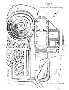
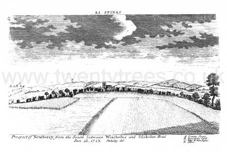
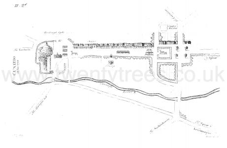
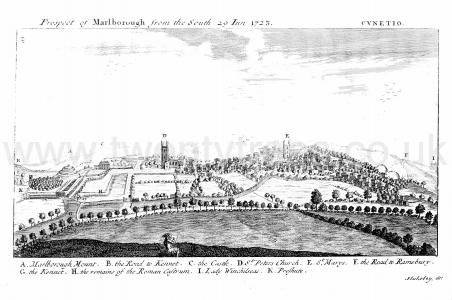
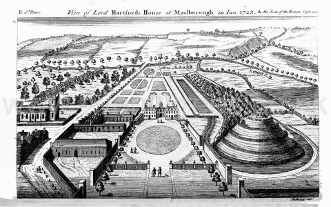
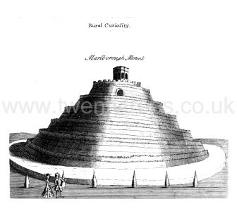
1724. Marlborough Mound [Map]. William Stukeley (age 36). Itinerarium Curiosum. Or, an Account of the Antiquitys and Remarkable Curiositys in Nature or Art, Observ'd in Travels thro' Great Britain. Illustrated with Copper Prints. Centuria I., London: Printed for the Author, 1724
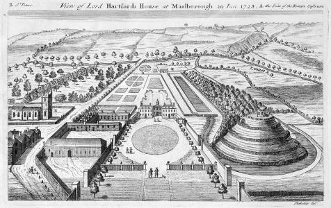
Colt Hoare 1812. Little more is now to be added to this Station, though many interesting relics, both of British and Roman antiquity, remain to be described in the immediate environs of the town of Marlborough; but as they do not come within the limits prescribed to this Station, they cannot with propriety be inserted. One remarkable earthen-work however, must not be passed over in silence. I allude to the mount [Marlborough Mound [Map]] within the gardens of the Castle Inn, a huge pile of earth, and inferior in proportions only to Silbury Hill [Map] near Abury, PLATE IV. No. 1. Each are situated on the river Kennet; the one near its source, the other near its margin; and I have no doubt but that in ancient times each had some corresponding connection with the other. In more modern times, when the present inn was the hospitable mansion of the Hertford farniiy, this stately mound was converted into a hill of pleasure: on the ground floor a cavern was excavated and ornamented as a grotto, with shell-work, &c.; the sides sliced down so as to form a spiral walk around it, fenced with parapet hedges, and the summit crowned with a summer-house; of which, Dr. Stukeley has given a view in his Itinerarium Curiosum. Still, however, notwithstanding all these inappropriate decorations, it assumes an imposing appearance, This mound has been so mutilated, as well as lowered in its height, that it is impossible to calculate an exact measurement of either its circumference or height; but as nearly as we could guess by a trial with our chains, wc found the base to be about one-thousand feet in circumference, and the diameter of the summit one-hundred and ten feet.
It appears that the Marlborough Mound [Map] is visible from Silbury Hill [Map] - the blue line on the Schematic. If it is it suggests the Marlborough Mound and Silbury Hill were constructed for the same purpose?
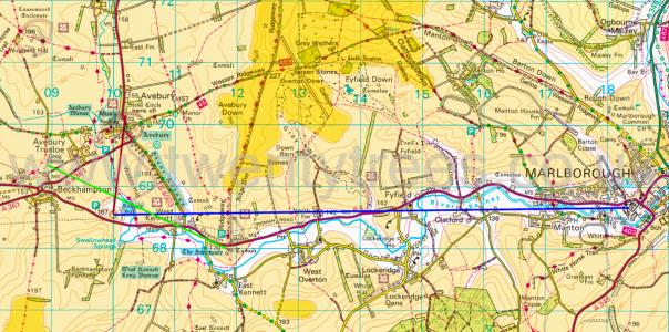 The light orange is land above 150m. The dark orange is land above 200m.