Europe, British Isles, North-Central England, Derbyshire, Amber Valley
Amber Valley, Derbyshire is in Derbyshire.
Europe, British Isles, North-Central England, Derbyshire, Amber Valley, Alfreton [Map]
Around 1462 John Ormond was born illegitimately to John Butler 6th Earl Ormonde (age 40) and Reynalda Obrien at Alfreton [Map].

James Ormond was born illegitimately to John Butler 6th Earl Ormonde and Reynalda Obrien at Alfreton [Map].

Europe, British Isles, North-Central England, Derbyshire, Amber Valley, Alfreton, South Normanton [Map]
In 1726 Jedediah Strutt was born in South Normanton, Alfreton [Map].
Europe, British Isles, North-Central England, Derbyshire, Amber Valley, Ambergate [Map]
The River Derwent rises on Bleaklow [Map] after which it passes Bamford [Map], Hope, Derbyshire [Map], Hathersage [Map], Grindleford [Map], Baslow, Derbyshire [Map], Chatsworth House [Map] passing under Chatsworth Bridge [Map], Rowsley [Map] which it is joined by the Derbyshire River Wye, Matlock [Map], Matlock Bath [Map], Cromford [Map], Ambergate [Map] where it is joined by the River Amber. After Ambergate [Map] it passes Belper, Derbyshire [Map], Duffield, Derbyshire [Map] then flows through the centre of Derby [Map] after which it joins the River Trent around 1.4 Km east of [Map].
Europe, British Isles, North-Central England, Derbyshire, Amber Valley, Belper [Map]
The River Derwent rises on Bleaklow [Map] after which it passes Bamford [Map], Hope, Derbyshire [Map], Hathersage [Map], Grindleford [Map], Baslow, Derbyshire [Map], Chatsworth House [Map] passing under Chatsworth Bridge [Map], Rowsley [Map] which it is joined by the Derbyshire River Wye, Matlock [Map], Matlock Bath [Map], Cromford [Map], Ambergate [Map] where it is joined by the River Amber. After Ambergate [Map] it passes Belper, Derbyshire [Map], Duffield, Derbyshire [Map] then flows through the centre of Derby [Map] after which it joins the River Trent around 1.4 Km east of [Map].
Europe, British Isles, North-Central England, Derbyshire, Amber Valley, Birchover
Europe, British Isles, North-Central England, Derbyshire, Amber Valley, Birchover, Bradley Rocks [Map]
Filmed in 1987 The Princess Bride locations include:
Bradley Rocks, Birchover [Map]: Buttercup's farm.
Haddon Hall [Map]: Prince Humperdinck's Castle.
Cave Dale, Castleton [Map]: Buttercup shoves herself and Dread Pirate Roberts down a hill.
Lathkill Dale [Map]: The Battle of Wits.
Robin Hood's Stride [Map]: Dread Pirate Roberts fights Fezzik.
Carl Wark [Map]: Buttercup and Dread Pirate Roberts cross the moors.
Europe, British Isles, North-Central England, Derbyshire, Amber Valley, Birchover, Rowtor Rocks [Map]
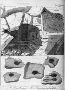
Archaeologia Volume 6 Section XIII. In Plate XIV. N° 5. are plans of rock basons, at about a quarter of a mile west of Bradley rocks. On a hill stands another group, called Carciff or Crackcliff. Among these are four very perfect rock basons. That marked 1 is on the top of Rowter rocks [Map], the stone nine feet by seven feet eleven inches; the diameter of the bason at the top two feet seven inches by one foot eleven inches; the other four are on the top of Cardiff. N° 2. stands close to a precipice, too hazardous to measure. The stone No 3. is seven feet in length, diameter of the bason two feet. The stone N° 4. is five feet, the bason two feet fix inches. The stone N° 5. is nine feet four inches, the larger bason three feet diameter, the other two feet. These basons appear to have been the work of art, and have in many places the marks of the tool. On the east and west side of Stanton Moor are several large rocks and stones, none of which have basons, nor are they to be found but on rocks that stand on hills, and in the neighbourhood of Druidical remains.
Plate XIV. N° 6. is a ground plan and view of a hermitage in a cave at the foot of Carcliff rocks. At the east end of the cave is a crucifix, the figure three feet high, cut out of the solid rock in high relief, the sculpture not bad; on the top of the cross there appears to have been something like letters, but now so defaced by time as not to be made out; on the left hand of the crucifix is a niche, as if intended for a statue. Facing the entrance are the remains of seats hewed out of the rock. The length of the cave from east to west is eleven feet; depth to the seats marked 1 nine feet, from the seats to the corner five feet. This little recess seems to have been the bed place of the hermit, and has been separated from the seats by rails, as appears from the holes marked 2. Height of the cave seven feet.

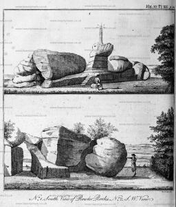
Archaeologia Volume 6 Section XIII. Plate XII N° I. is a south view of Rowter rocks [Map], where (a) is a rock bason. The pillar on the top was set up a few years ago to support a weather-cock..
N° 2. is a south-well: view of Rowter rocks, with the rocking stone marked (b); the circumference of which is twenty-eight feet seven inches. There are several caves among these rocks on the north side.

Europe, British Isles, North-Central England, Derbyshire, Amber Valley, Crich [Map]
In 1822 George Graham was born at Crich [Map].
Europe, British Isles, North-Central England, Derbyshire, Amber Valley, Denby [Map]
On 19 Aug 1646 John Flamsteed was born in Denby [Map].
Europe, British Isles, North-Central England, Derbyshire, Amber Valley, Dethick
Europe, British Isles, North-Central England, Derbyshire, Amber Valley, Duffield [Map]
The River Derwent rises on Bleaklow [Map] after which it passes Bamford [Map], Hope, Derbyshire [Map], Hathersage [Map], Grindleford [Map], Baslow, Derbyshire [Map], Chatsworth House [Map] passing under Chatsworth Bridge [Map], Rowsley [Map] which it is joined by the Derbyshire River Wye, Matlock [Map], Matlock Bath [Map], Cromford [Map], Ambergate [Map] where it is joined by the River Amber. After Ambergate [Map] it passes Belper, Derbyshire [Map], Duffield, Derbyshire [Map] then flows through the centre of Derby [Map] after which it joins the River Trent around 1.4 Km east of [Map].
Europe, British Isles, North-Central England, Derbyshire, Amber Valley, Duffield, The Hollies
On 05 Jun 1886 Llewellynn Jewitt (age 69) died at The Hollies, Duffield.
Europe, British Isles, North-Central England, Derbyshire, Amber Valley, Heanor [Map]
In Jul 1555 Henry Garnet Jesuit was born in Heanor [Map].
Around 18 Oct 1750 Edward Miller Mundy was born to Edward Mundy (age 44) at Heanor [Map].
Europe, British Isles, North-Central England, Derbyshire, Amber Valley, Kirk Langley [Map]
In 1507 Henry Pole was born to Henry Pole (age 37) and Ursula Twyford at Kirk Langley [Map].
In 1522 Thomas Twyford (age 83) died at Kirk Langley [Map].
Henry Pole died at Kirk Langley [Map].
Europe, British Isles, North-Central England, Derbyshire, Amber Valley, Oakerthorpe [Map]
Icknield Street 18d Derby to Chesterfield. From Derventio [Map] aka Derby Icknield Street takes a new alignment past Morley [Map], Smithy Houses [Map], Street Lane [Map], Higham [Map], Oakerthorpe [Map], Clay Cross [Map] crossing the River Rother before arriving at Chesterfield [Map].
Europe, British Isles, North-Central England, Derbyshire, Amber Valley, Smithy Houses [Map]
Icknield Street 18d Derby to Chesterfield. From Derventio [Map] aka Derby Icknield Street takes a new alignment past Morley [Map], Smithy Houses [Map], Street Lane [Map], Higham [Map], Oakerthorpe [Map], Clay Cross [Map] crossing the River Rother before arriving at Chesterfield [Map].
Europe, British Isles, North-Central England, Derbyshire, Amber Valley, South Wingfield [Map]
On 04 Jan 1456 Ralph Cromwell 3rd Baron Cromwell (age 53) died at South Wingfield [Map]. He was buried at the Collegiate Church, Tattershall. Baron Cromwell became abeyant between his his two nieces, daughters of his sister Maud Cromwell: Maud Stanhope 4th Baroness Cromwell Baroness Willoughby Eresby and Joan Stanhope.

Europe, British Isles, North-Central England, Derbyshire, Amber Valley, South Wingfield, Wingfield Manor [Map]
In Jun 1569 George Talbot 6th Earl of Shrewsbury (age 41) was Keeper of Mary Queen of Scots (age 26) at Wingfield Manor [Map].

Archaeologia Volume 32 Section X. We left the Queen at Tutbury [Map] in Staffordshire, a castle which was a member of the Duchy of Lancaster. Between the 9th and the 18th of April, 1569, she was removed to a house of the Earl of Shrewsbury, called Winfield Manor [Map]. This house was in Derbyshire, and not more than ten miles distant from Hardwick [Map]. She remained at Winfield [Map] till the 21st of September, and all the letters of hers which exist, written during that period, are dated at Winfield [Map]. The utmost that can be supposed in reference to the question before us is that she might possibly be allowed to make excursions on horseback to some distance from her prison, when Hardwick [Map] might be comprehended in the range. But there is every reason to believe that the restraint at this period was too rigid to allow of such distant excursions, the Queen having by this time become a centre of political and religious disaffection, and the deliverance of her from an unjust restraint an object of ambition to enterprising youth of the time. Several attempts were, we know, made to effect her release during this sojourn at Winfield [Map]. This of course would be met by increased vigilance in her keeper. But when there were indications of a movement in the North, Winfield [Map] was not deemed sufficiently secure, and she was carried back to Tutbury [Map], from whence, during the rebellion of the two northern earls, she was taken, for still greater security, to Coventry [Map]. She was soon reconducted to Tutbury [Map], where she remained till the end of May, 1570.

Europe, British Isles, North-Central England, Derbyshire, Amber Valley, Street Lane [Map]
Icknield Street 18d Derby to Chesterfield. From Derventio [Map] aka Derby Icknield Street takes a new alignment past Morley [Map], Smithy Houses [Map], Street Lane [Map], Higham [Map], Oakerthorpe [Map], Clay Cross [Map] crossing the River Rother before arriving at Chesterfield [Map].
Europe, British Isles, North-Central England, Derbyshire, Amber Valley, Wooley [Map]
The River Amber rises near Kelstedge, Derbyshire [Map] after which it flows through Ashover, Derbyshire [Map], Wooley [Map] before joining the River Derwent at Ambergate [Map].