

Annals of the six Kings of England by Nicholas Trivet
Translation of the Annals of the Six Kings of England by that traces the rise and rule of the Angevin aka Plantagenet dynasty from the mid-12th to early 14th century. Written by the Dominican scholar Nicholas Trivet, the work offers a vivid account of English history from the reign of King Stephen through to the death of King Edward I, blending political narrative with moral reflection. Covering the reigns of six monarchs—from Stephen to Edward I—the chronicle explores royal authority, rebellion, war, and the shifting balance between crown, church, and nobility. Trivet provides detailed insight into defining moments such as baronial conflicts, Anglo-French rivalry, and the consolidation of royal power under Edward I, whose reign he describes with particular immediacy. The Annals combines careful year-by-year reporting with thoughtful interpretation, presenting history not merely as a sequence of events but as a moral and political lesson. Ideal for readers interested in medieval history, kingship, and the origins of the English state, this chronicle remains a valuable and accessible window into the turbulent world of the Plantagenet kings.
Available at Amazon in eBook and Paperback format.
 Aston, Derbyshire
 Bamford, Derbyshire
 Bradwell, Derbyshire
 Castleton, Derbyshire
 Cronkstone Hill, Derbyshire
 Hathersage, Derbyshire
 Hope, Derbyshire
 Offerton Moor
Hope Valley is in High Peak, Derbyshire.
In 1367 John Melton was born to William Ricardus Melton [aged 27] at Aston, Derbyshire [Map]. He married before 1398 Margaret Clifford, daughter of Roger Clifford 5th Baron Clifford and Maud Beauchamp Baroness Clifford, and had issue.
The River Derwent rises on Bleaklow, Derbyshire [Map] after which it passes Bamford, Derbyshire [Map], Hope, Derbyshire [Map], Hathersage, Derbyshire [Map], Grindleford, Derbyshire [Map], Baslow, Derbyshire [Map], Chatsworth House, Derbyshire [Map] passing under Chatsworth Bridge [Map], Rowsley, Derbyshire [Map] which it is joined by the Derbyshire River Wye, Matlock, Derbyshire [Map], Matlock Bath, Derbyshire [Map], Cromford, Derbyshire [Map], Ambergate, Derbyshire [Map] where it is joined by the River Amber. After Ambergate, Derbyshire [Map] it passes Belper, Derbyshire [Map], Duffield, Derbyshire [Map] then flows through the centre of Derby, Derbyshire [Map] after which it joins the River Trent around 1.4 Km east of Cavendish Bridge, Leicestershire [Map].
On 14th July 1822 Elizabeth Graham was born at Bradwell, Derbyshire [Map].
Filmed in 1987 The Princess Bride locations include:
Bradley Rocks, Birchover [Map]: Buttercup's farm.
Haddon Hall, Derbyshire [Map]: Prince Humperdinck's Castle.
Cave Dale, Castleton [Map]: Buttercup shoves herself and Dread Pirate Roberts down a hill.
Lathkill Dale, Derbyshire [Map]: The Battle of Wits.
Robin Hood's Stride [Map]: Dread Pirate Roberts fights Fezzik.
Carl Wark [Map]: Buttercup and Dread Pirate Roberts cross the moors.
Chronicle of Henry of Huntingdon Book 1. There are four things in England which are very remarkable. One is that the winds issue with such great violence from certain caverns in a mountain called the Peak [Probably the Devil's Arse [Map]] that It ejects matters thrown into them, and whirling them about in the air carries them to a great distance. The second is at Stonehenge, where stones of extraordinary dimensions are raised as columns, and others are fixed above, like lintels of immense portals; and no one has been able to discover by what mechanism such vast masses of stone were elevated, nor for what purpose they were designed. The third is at Chedder-hole1, where there is a cavern which many persons have entered, and have traversed a great distance under ground, crossing subterraneous streams, without finding any end of the cavern. The fourth wonder is this, that in some parts of the countiy the rain is seen to gather about the tops of the hills, and forthwith to fall on the plains.
Note 1. Wookey Hole, in Cheddar Cliffs, under the Mendip Hills, in Somersetshire.
The Seven Wonders Of England by Philip Sidney. IV.
Peak hath a cave [Map], whose narrow entries find
Large rooms within where drops distil amain:
Till knit with cold, though there unknown remain,
Deck that poor place with alabaster lined.
Mine eyes the strait, the roomy cave, my mind;
Whose cloudy thoughts let fall an inward rain
Of sorrow's drops, till colder reason bind
Their running fall into a constant vein
Of truth, far more than alabaster pure,
Which, though despised, yet still doth truth endure.
Samuel Pepys' Diary. 19th January 1663. He, the next day (of which the Duke was warned by somebody that saw the passion my Lord Chesterfield [aged 29] was in the night before), went and told the Duke how much he did apprehend himself wronged, in his picking out his lady of the whole Court to be the subject of his dishonour; which the Duke [aged 29] did answer with great calmness, not seeming to understand the reason of complaint, and that was all that passed but my Lord did presently pack his lady into the country in Derbyshire, near the Peake; which is become a proverb at Court, to send a man's wife to the Devil's arse a' Peake [Map], when she vexes him.
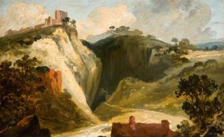
Before 1845. William James Müller [aged 32]. "The Peak Cavern [Map], Derbyshire, Peveril Castle [Map]".
Mam Tor Hill Fort is also in Peak District Iron Age Hill Forts.
Mam Tor Hill Fort [Map] is an Univallate Hill Fort dating to around 1200BC.
Peverell Castle, Derbyshire is also in Castles in Derbyshire.
Annals of the six Kings of England by Nicholas Trivet
Translation of the Annals of the Six Kings of England by that traces the rise and rule of the Angevin aka Plantagenet dynasty from the mid-12th to early 14th century. Written by the Dominican scholar Nicholas Trivet, the work offers a vivid account of English history from the reign of King Stephen through to the death of King Edward I, blending political narrative with moral reflection. Covering the reigns of six monarchs—from Stephen to Edward I—the chronicle explores royal authority, rebellion, war, and the shifting balance between crown, church, and nobility. Trivet provides detailed insight into defining moments such as baronial conflicts, Anglo-French rivalry, and the consolidation of royal power under Edward I, whose reign he describes with particular immediacy. The Annals combines careful year-by-year reporting with thoughtful interpretation, presenting history not merely as a sequence of events but as a moral and political lesson. Ideal for readers interested in medieval history, kingship, and the origins of the English state, this chronicle remains a valuable and accessible window into the turbulent world of the Plantagenet kings.
Available at Amazon in eBook and Paperback format.
In 1157 brothers King Malcolm IV of Scotland [aged 15] and King William I of Scotland [aged 14] paid homage to King Henry "Curtmantle" II of England [aged 23] at Peverell Castle, Derbyshire [Map].
King Malcolm IV of Scotland was deprived of his lands in Cumbria and titles by King Henry "Curtmantle" II of England. Earl of Northumbria forfeit.
King Malcolm IV of Scotland was granted 5th Earl Huntingdon, 5th Earl of Northampton.
King William I of Scotland was deprived of the Earldom of Northumbria.
Cronkstone Hill Barrow is also in Peak District Bronze Age Barrows.
Vestiges of the Antiquities of Derbyshire. On May 19, 1825, an examination of a barrow on the apex of Cronkstone Hill [Map], led to the discovery of a cist, measuring about four feet square, constructed of large stones, which contained a perfect human skeleton, lying on its right side; at the left side of the head, lay the lower part of the horn of a large deer, which measured eleven inches in length, and nine and a quarter in circumference.
Ten Years' Digging. On the afternoon we re-opened the barrow on Cronkstone Hill [Map] (the next eminence), which was examined by Mr. William Bateman, in 1825 (Vestiges, p. 33). A short distance east from the centre was a large irregularly shaped grave in the rock, the bottom of which was upwards of five feet below the apex of the mound, within it lay the skeleton of a full sized person who had suffered from a morbid enlargement of the head of the right humerus; as usual, in the early interments, he lay in a contracted posture, with a circular instrument of flint near the head, and surrounded by rats' bones. A few inches above this skeleton was a deposit of calcined human bones, apparently interred at the same time as it. There may probably be other interments in the mound, which is about 20 yards diameter.
Hurdlow Barrow is also in Peak District Bronze Age Barrows.
Ten Years' Digging. On the 21st of July we opened a small tumulus [Map] [Hurdlow Barrow [Map]] on a hill above the High Peak Railway, near Hurdlow, which had been cut through the centre, but the imperfect manner in which investigations of this kind were formerly executed, afforded a chance of our finding something. We discovered that the former excavators had removed one side of a small rectangular cist, which was placed a little to the side of their trench; its other sides were intact, and the earth inside did not seem to have been disturbed, yet we found nothing within but a horse's tooth, a bit of thin bronze, and a few imperfectly burnt bones.
The River Derwent rises on Bleaklow, Derbyshire [Map] after which it passes Bamford, Derbyshire [Map], Hope, Derbyshire [Map], Hathersage, Derbyshire [Map], Grindleford, Derbyshire [Map], Baslow, Derbyshire [Map], Chatsworth House, Derbyshire [Map] passing under Chatsworth Bridge [Map], Rowsley, Derbyshire [Map] which it is joined by the Derbyshire River Wye, Matlock, Derbyshire [Map], Matlock Bath, Derbyshire [Map], Cromford, Derbyshire [Map], Ambergate, Derbyshire [Map] where it is joined by the River Amber. After Ambergate, Derbyshire [Map] it passes Belper, Derbyshire [Map], Duffield, Derbyshire [Map] then flows through the centre of Derby, Derbyshire [Map] after which it joins the River Trent around 1.4 Km east of Cavendish Bridge, Leicestershire [Map].

Carl Wark is also in Peak District Iron Age Hill Forts.
Archaeologia Volume 7 Section XX. Sir,
I am very glad to find that the ingenious major Rooke [aged 61] has furnished the Society with drawings of that curious remain of very early fortification, the Caers-work [Map] (or, as the name was given me, the Carles-work) near Hathersage in Derbyshire. It was first noticed in print (I believe) in the tour into that country which I ventured to lay before the public this year, but is much better illustrated by the major. If it will not be improper to offer the Society two drawings in addition to those which Mr. Rooke has sent, I will beg you to present them.
The number of curiosities of the highest antiquity which that county affords, well deserves attention, and (I speak experimentally) the traveller who shall go in search of them will no where find a greater variety of scenery, than is there presented in succession to his eye. The antiquary will, however, have to lament that while turnpike roads facilitate his visit, the barbarity of turnpike surveyors will destroy the objects of his search; barrows, druidical temples, rocking stones, and whatever comes in their way, fall a prey to their sacrilegious hands. It has been the case with one rocking stone near this Work, which was too near the road to escape; — nimium vicina Cremona! [Note. A quote from Virgil's Eclogues "Cremona is too close"]
Adjoining to Hathersage church yard is a small circular fortification; perhaps that of the enemy which might cause the rude one on the Moor. I am, &c.
William Bray.
Archaeologia Volume 7 Section XIX. A further account of some Druidical Remains [Carl Wark [Map]] in Derbyshire. By Hayman Rooke [aged 62], Esq. Read December 11th, 1785.
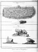
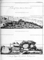
Derbyshire Archaeological Journal Volume 30 1908 Page 155. [Fol 38.] Strawberry Lee, &c
"July 1824, by permission of B. B. Steade Esqr of Beauchief Hall (agent to Peter Pegge Burnell Esqr) I opened a remarkably ccnspicuous and well shaped tumulus at Strawberry Lee1, near Totley, in Derbyshire, which was supposed to have been a barrow. We dug through the side to the centre withoout discovering the least sign of its being a funeral mound.
"The same day, I opened several of a great number of small tumuli near the Carle's Wark [Map], close to the Burbage Brook, and near the road from Fox house to Hathersage, without finding any thing of interest. These were certainly not barrows2."
S. Mitchell [aged 21] June 1824.
Note 1. 11½ miles west of Totley. No barrow is here marked on the Ordnance Survey
Note 2 A good day's work, truly! Even with a large gang of labourers it would be impossible to satisfactorily prove whether all these mounds, including that at Strawberry Lee which is about 4 miles away, were or were not burial-places, in so short a time; but a similar haste was characteristic of much of Thomas Bateman's work, the result being that nearly all the barrows which he opened, and which have since been further examined, have yielded internents which escaped his spade.
Vestiges of the Antiquities of Derbyshire. The same gentleman, in 1826, opened several of the small tumuli in the vicinity of the "Cairs Work," or "Carls Wark [Map]," near Hathersage, and found them to contain nothing more than simple deposits of calcined bones, without the accompaniment of either urns or instruments. They may therefore be presumed to have been cast up at a very early period indeed. Shortly afterwards, Mr. Mitchell had an opportunity of opening a similar cluster of barrows on Broomhead Moors, in Yorkshire, close to the edge of Derbyshire, which displayed just the same features as those at the Carls Wark.
Filmed in 1987 The Princess Bride locations include:
Bradley Rocks, Birchover [Map]: Buttercup's farm.
Haddon Hall, Derbyshire [Map]: Prince Humperdinck's Castle.
Cave Dale, Castleton [Map]: Buttercup shoves herself and Dread Pirate Roberts down a hill.
Lathkill Dale, Derbyshire [Map]: The Battle of Wits.
Robin Hood's Stride [Map]: Dread Pirate Roberts fights Fezzik.
Carl Wark [Map]: Buttercup and Dread Pirate Roberts cross the moors.
Abbot John Whethamstede’s Chronicle of the Abbey of St Albans
Abbot John Whethamstede's Register aka Chronicle of his second term at the Abbey of St Albans, 1451-1461, is a remarkable text that describes his first-hand experience of the beginning of the Wars of the Roses including the First and Second Battles of St Albans, 1455 and 1461, respectively, their cause, and their consequences, not least on the Abbey itself. His text also includes Loveday, Blore Heath, Northampton, the Act of Accord, Wakefield, and Towton, and ends with the Coronation of King Edward IV. In addition to the events of the Wars of the Roses, Abbot John, or his scribes who wrote the Chronicle, include details in the life of the Abbey such as charters, letters, land exchanges, visits by legates, and disputes, which provide a rich insight into the day-to-day life of the Abbey, and the challenges faced by its Abbot.
Available at Amazon in eBook and Paperback format.
Archaeologia Volume 7 Section XIX. About two miles west of Hathersage Moor, and separated by a cultivated valley, is Highlow Moor. At the east end is a large tumulus [Map] [Highlow Moor Barrows [Map]] of earth and stone, one hundred and eighty-nine feet in circumference, which seemed to have been opened at the top and side; near it are five small ones. At about fix hundred yards from these, at the West end of the Moor, are three small tumuli of earth and stone, but little raised from the ground, the largest twenty-four feet diameter. At the East end of Alney Moor adjoining to Highlow moor is a circle [Smelting Hill Stone Circle [Map]] inclosed with a vallum of earth, within which are four upright stones, eighteen inches out of the ground. In the year 1761, my worthy and learned friend Mr. Pegge of Whittington explored these moors, and says, that there were then nine large stones standing at equal dillances, and that on Overton Moor, which joins to the above, was a large circle of stones, whereof some stood on end, but there are now hardly any traces to be seen of this circle, the stones having been all taken up for the repair of roads and walls.
Archaeologia Volume 7 Section XIX. About two miles west of Hathersage Moor, and separated by a cultivated valley, is Highlow Moor. At the east end is a large tumulus [Map] [Highlow Moor Barrows [Map]] of earth and stone, one hundred and eighty-nine feet in circumference, which seemed to have been opened at the top and side; near it are five small ones. At about fix hundred yards from these, at the West end of the Moor, are three small tumuli of earth and stone, but little raised from the ground, the largest twenty-four feet diameter. At the East end of Alney Moor adjoining to Highlow moor is a circle [Smelting Hill Stone Circle [Map]] inclosed with a vallum of earth, within which are four upright stones, eighteen inches out of the ground. In the year 1761, my worthy and learned friend Mr. Pegge of Whittington explored these moors, and says, that there were then nine large stones standing at equal dillances, and that on Overton Moor, which joins to the above, was a large circle of stones, whereof some stood on end, but there are now hardly any traces to be seen of this circle, the stones having been all taken up for the repair of roads and walls.
On 20th October 1846 Matilda Graham was born to George Graham [aged 24] and Elizabeth Graham [aged 24] at Hope, Derbyshire [Map]. She married 24th September 1866 William Waterhouse and had issue.
On 7th March 1868 Susannah Jane Beverly was born to James Beverly [aged 25] at Hope, Derbyshire [Map]. She married before 15th November 1899 Joseph Singleton and had issue.
The River Derwent rises on Bleaklow, Derbyshire [Map] after which it passes Bamford, Derbyshire [Map], Hope, Derbyshire [Map], Hathersage, Derbyshire [Map], Grindleford, Derbyshire [Map], Baslow, Derbyshire [Map], Chatsworth House, Derbyshire [Map] passing under Chatsworth Bridge [Map], Rowsley, Derbyshire [Map] which it is joined by the Derbyshire River Wye, Matlock, Derbyshire [Map], Matlock Bath, Derbyshire [Map], Cromford, Derbyshire [Map], Ambergate, Derbyshire [Map] where it is joined by the River Amber. After Ambergate, Derbyshire [Map] it passes Belper, Derbyshire [Map], Duffield, Derbyshire [Map] then flows through the centre of Derby, Derbyshire [Map] after which it joins the River Trent around 1.4 Km east of Cavendish Bridge, Leicestershire [Map].

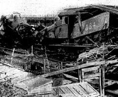
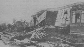
On the 3rd September 1925 an express passenger train collided with a ballast train at Hope Station [Map].
Report written by Lieut. Col. A. H. L. Mount: "In this case the 3 p.m. up express passenger train, Manchester Central to Sheffield, travelling at high speed under clear signals, collided head-on with a stationary down ballast train which had just previously been shunted from the down to the up line for the purpose of permitting a following down mineral train to pass. As a result, I regret to report that the driver and the fireman of the express, and a platelayer, one of a gang of men employed with the ballast train, succumbed shortly afterwards in hospital. One passenger was seriously injured, while nine others, the guard of the ballast train and two platelayers received minor injuries or suffered from shock. It was fortunate that the express was lightly loaded and that the brake compartment of the first coach was leading."
Peveril Castle is also in Castles in Derbyshire.
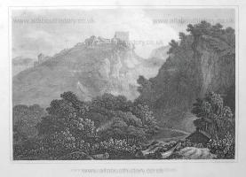
Peveril Castle [Map]. J Greig.
Before 1845. William James Müller [aged 32]. "The Peak Cavern [Map], Derbyshire, Peveril Castle [Map]".
Gesta Regis Henrici by Benedict of Peterborough. Meanwhile, Richard, Duke of Normandy, gave to his brother John the daughter of the Earl of Gloucester along with the County of Gloucester, and the castle of Marlborough [Map] along with that honour; and the castle of Ludgershall [Map] along with that honour; and the castle of Peak [Map] along with that honour; and the castle of Bolsover [Map]; and all the land that belonged to William Peverel; and the town of Nottingham along with that honour, and the castle of Lancaster [Map] along with that honour, and Derbyshire, and the honour of Wallingford, and the honour of Tickhill [Map], and many other things which are too long to enumerate individually. He gave him all these things with the forests, towns, and all their other appurtenances.
Interim Ricardus dux Normanniæ dedit Johanni fratri suo filiam comitis Gloucestriæ cum comitatu Gloucestriæ, et castellum de Merleberg cum honore illo; et castellum de Lutegareshale cum honore illo; et castellum de Pech cum honore illo; et castellum de Boleshoveres; et totam terram que fuit Willelmi Peverel; et villam de Notingham cum honore illo, et castellum de Lounecastre cum honore illo, et Derebisiram, et honorem de Walinford, et honorem de Tikehil, et multa alia quae longum est enumerare per singula. Hæc omnia dedit ei cum forestis, villis et aliis omnibus pertinentiis suis.